A Short Flight to Disaster: Agusta A109 Mountain CFIT in Marginal Weather (N109W)
On 19 November 2016 Agusta A109A II N109W was destroyed in a Controlled Flight Into Terrain (CFIT) accident at Monte Rho, near Varese, Italy at c 2950ft AMSL. One of the three occupants was killed and the other two seriously injured. Italy’s Agenzia Nazionale per la Sicurezza del Volo (ANSV) released its safety investigation report, in Italian only, on 21 December 2020. At the time of the accident, the weather in the area were characterized by ANSV as “poor visibility and cloud-covered peaks”.
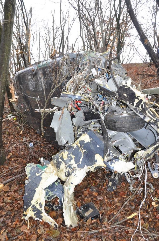
![Wreckage of Agusta A109A II N109W (Credit: Italian National Alpine and Speleological Rescue Corps [Corpo Nazionale Soccorso Alpino e Speleologico - CNSAS]0](/wp-content/uploads/2021/01/n109w-a109-cfit-wreckage.jpg)
Wreckage of Agusta A109A II N109W (Credit: Italian National Alpine and Speleological Rescue Corps [Corpo Nazionale Soccorso Alpino e Speleologico – CNSAS])
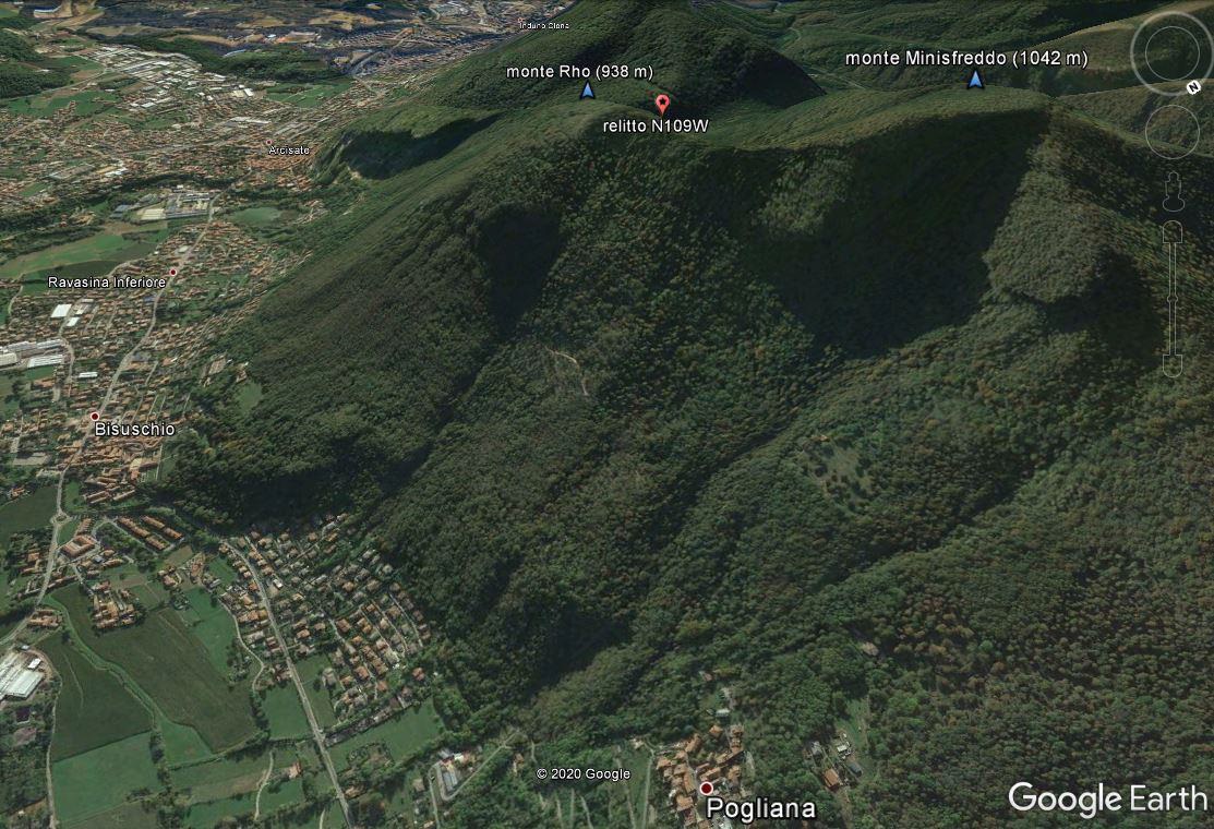
Monte Rho and Accident Site of Agusta A109A II N109W (Credit: ANSV)
The Accident Flight
The US registered aircraft was registered to a trustee company in Delaware, US, however the ANSV describe it as being operated non-commercially by Execavia Ltd (registered in Valletta, Malta), although the ‘user’ of the helicopter was BG Air SA based in Lugano, Switzerland.
The pilot was a 57-year-old Italian with a PPL(H) issued by ENAC and CPL(H) issued by FAA, and 4400 hours of flight time. The pilot and a female passenger (seated in the front left seat) arrived in Lugano from Caiolo, Italy at c14:00 Local Time. A male passenger boarded and the aircraft departed at 14:12 Local Time, heading south, having filed a VFR flight plan. Lugano TWR confirmed that the N109W was the only known traffic present in the area and once at Visual Reporting Point “S” they were instructed to change to the frequency of the Milan FIC.
ANSV comment that at that time “the weather conditions did not seem critical” but while flying over Lake Lugano the pilot noted a relatively low cloud ceiling.
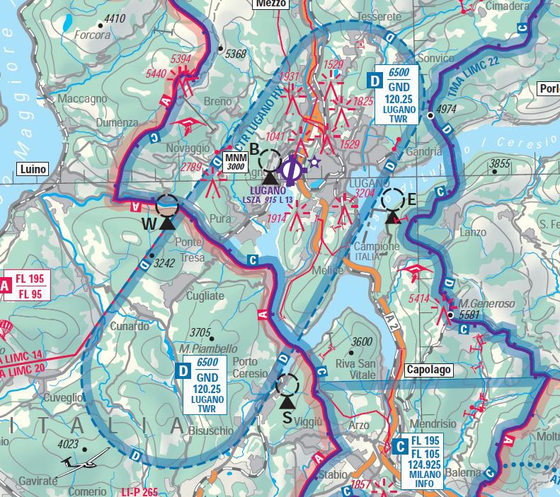
In particular, towards the southern edge of the lake, at the limit of the Lugano CTR, towards the VRP “S”, there was low haze, which made it difficult to see the terrain.
Chart of Lugano CTR showing VRP “S” (Credit: ANSV)
Consequently, in order not to be forced to fly at a very low altitude, he had decided to “aim for a hill, crossing which I would have had the whole Po Valley in front of me”. Since there were clouds on the sides of the aforementioned hill [Moute Rho], he decided to aim for the top of the same.
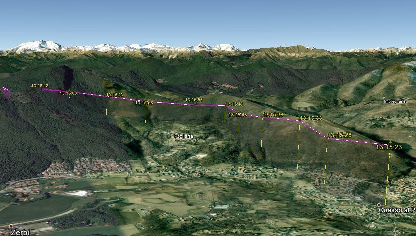
Flightpath of Agusta A109A II N109W (Credit: ANSV)
Flightpath of Agusta A109A II N109W (Credit: ANSV)
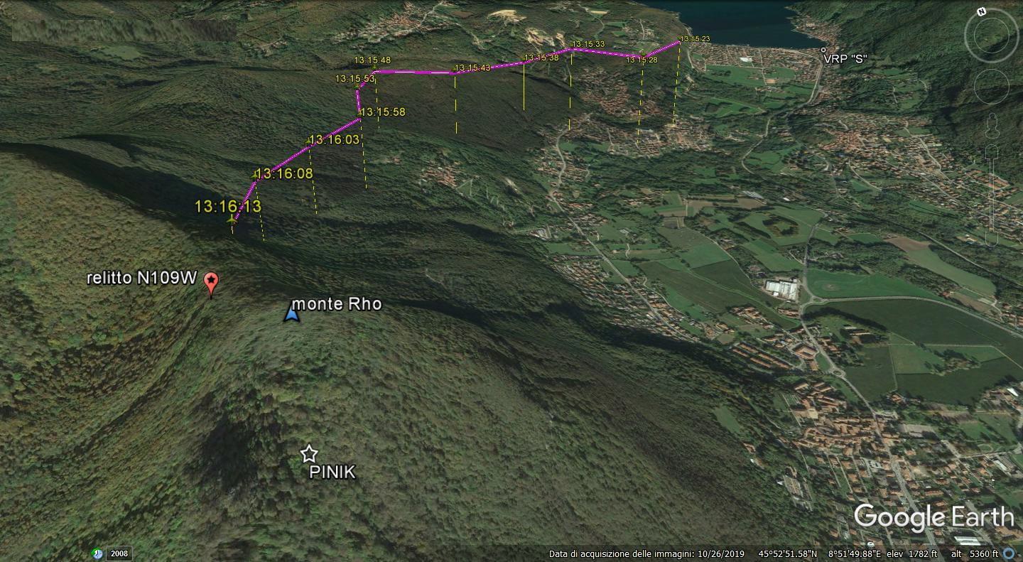
However, the helicopter’s rate of climb as insufficient and the helicopter contacted trees on the mountain, first with the tail and then the main rotor.
The pilot…did not feel a big impact, but a series of many small impacts up to the final impact with the ground.
The surviving passenger…immediately after taking off…started reading a newspaper; after a few minutes, he heard a bang, realizing the helicopter had crashed.
The fuselage came to rest on its left-hand side less than 5 minutes after take off.
Wreckage of Agusta A109A II N109W (Credit: ANSV)
No Emergency Locator Transmitter (ELT) signal was detected (investigators found the ELT turned off but could not determine if that occurred upon rescue or before the flight). Rescuers were informed of the accident by a mobile phone call from the pilot. The adverse weather and approaching darkness hampered the rescue operation and rescuers did not arrive on-site until 18:30 Local Time.
![Rescuers at the Agusta A109A II N109W Accident Site (Credit: Italian National Alpine and Speleological Rescue Corps [Corpo Nazionale Soccorso Alpino e Speleologico - CNSAS])](/wp-content/uploads/2021/01/n109w-a109-cfit-rescuers.jpg)
Rescuers at the Agusta A109A II N109W Accident Site (Credit: Italian National Alpine and Speleological Rescue Corps [Corpo Nazionale Soccorso Alpino e Speleologico – CNSAS])
ANSV Analysis
Investigators found an AV-MAP EKP V unit in the helicopter. This is a non-certified GPS mapping tool “usable only as a support for VFR navigation, not replacing the official documentation” or “on-board instrumentation”. The helicopter was unfortunately not equipped with a Terrain Avoidance and Warning System (TAWS) but the radalt low height warning was set at 200 ft.
The ANSV comment that radar data showed:
…an almost constant climb rate and horizontal speed. Taking into account the low intensity of the wind, it seems unlikely that the helicopter found itself in a leeward condition [such as a mountain wave], such as to limit its climbing performance…
[I]t would seem plausible that the pilot, due to the poor visibility existing in the area overflown, underestimated the actual distance from the ground and did not realize that the separation from the ground was rapidly reducing, due to the gradually increasing slope of the terrain, thus ending up hitting the tops of some trees.
Moreover, the course of the mountain ridge, initially parallel to the direction of flight necessary to reach the Po Valley and subsequently perpendicular….could have misled the pilot, making him believe that the route ahead was free, and then present itself as an unexpected obstacle.
The pilot’s decision to continue the flight in marginal conditions of visibility, documented by the evidence acquired during the investigation, appears to be determined by an inadequate risk assessment, associated with the rapid deterioration of the meteorological situation coupled with the mountainous terrain along the route.
[T]he evidence acquired leads us to believe that the planning of the flight from Lugano to Caiolo was decidedly inadequate in terms of assessing the meteorological conditions, which can be deduced from the examination of multiple sources.
![Wreckage of Agusta A109A II N109W (Credit: Italian National Alpine and Speleological Rescue Corps [Corpo Nazionale Soccorso Alpino e Speleologico - CNSAS])](/wp-content/uploads/2021/01/n109w-a109-cfit-wreckage-2.jpg)
Wreckage of Agusta A109A II N109W (Credit: Italian National Alpine and Speleological Rescue Corps [Corpo Nazionale Soccorso Alpino e Speleologico – CNSAS])
ANSV Conclusions
The following factors contributed significantly to this CFIT accident:
- Marginal weather conditions in the mountainous terrain where the accident occurred, which did not allow the safe continuation of the flight;
- Non-compliance with VFR flight rules and safety altitudes.
The following factors may have contributed:
- Operational pressure (deriving from the need to complete the transfer flight to Caiolo), which did not allow the pilot to consider an alternative plan, consisting, for example, of a return to the airport of departure;
- Excessive confidence of the pilot in his own ability to manage the flight in marginal or inferior meteorological conditions with respect to the minimum VFR conditions, in the light of his significant flight experience and knowledge of the area of operations;
- False security resulting from having a cartographic or portable GPS system on board.
Safety Resources
The European Safety Promotion Network Rotorcraft (ESPN-R) has a helicopter safety discussion group on LinkedIn. You may also find these Aerossurance articles of interest:
- CFIT Gangnam Style – Korean S-76C++ and Decision Making
- NTSB Investigation into AW139 Bahamas Night Take Off Accident
- Fatal Night-time UK AW139 Accident Highlights Business Aviation Safety Lessons
- HEMS AW109S Collided With Radio Mast During Night Flight
- Fatal B206L3 Cell Phone Discount Distracted CFIT
- Time Pressures and Take-Off Trim Trouble
- When Habits Kill – Canadian MD500 Accident
- EC120 Forgotten Walkaround
- An AW109SP, Overweight VIPs and Crew Stress
- Final Report: AS365N3 9M-IGB Fatal Accident
- Fatal Helicopter / Crane Collision – London Jan 2013
- Tragic Texan B206B3 CFIT in Dark Night VMC
- HEMS EC135T1 CFIT During Mountain Take Off in Poor Visibility
- HEMS A109S Night Loss of Control Inflight
- Air Ambulance A109S Spatial Disorientation in Night IMC
- NTSB on LA A109S Rooftop Hospital Helipad Landing Accident
- Helicopter Destroyed in Hover Taxi Accident
- Mid-Air Collision of Guimbal Cabri G2 9M-HCA & 9M-HCB: Malaysian AAIB Preliminary Report
- UPDATE 23 January 2021: US Air Ambulance Near Miss with Zip Wire and High ROD Impact at High Density Altitude
- UPDATE 29 January 2021: BK117 Impacts Sea, Scud Running off PNG
- UPDATE 5 February 2021: Inexperienced IIMC over Chesapeake Bay (Guimbal Cabri G2 N572MD): Reduced Visual References Require Vigilance
- UPDATE 2 April 2021: Windscreen Rain Refraction: Mountain Mine Site HESLO CFIT
- UPDATE 17 April 2021: Plan Continuation Bias & IIMC in Kenyan Police AW119 Accident
- UPDATE 24 July 2021: Loss of Bell 412 off Brazil Remains Unexplained
- UPDATE 31 July 2021: Low Recce of HEMS Landing Site Skipped – Rotor Blade Strikes Cable Cutter at Small, Sloped Site
- UPDATE 21 August 2021: Air Methods AS350B3 Night CFIT in Snow
- UPDATE 19 September 2021: A HEMS Helicopter Had a Lucky Escape During a NVIS Approach to its Home Base
- UPDATE 11 February 2022: Erratic Flight in Marginal Visibility over New York Ends in Tragedy
- UPDATE 12 March 2022: Black Hawk Scud Running in Tennessee: IIMC & CFIT
- UPDATE 28 December 2022: Night Mountain Rescue Hoist Training Fatal CFIT
EHEST Leaflet HE7: Techniques for Helicopter Operations in Hilly and Mountainous Terrain:
EHEST Leaflet HE 13 Weather Threat For VMC Flights:

Recent Comments