Drone / Helicopter Mid Air Collision over Los Angeles City Hall ‘Probable’ Say NTSB (Airbus AS30B2 N71HD)
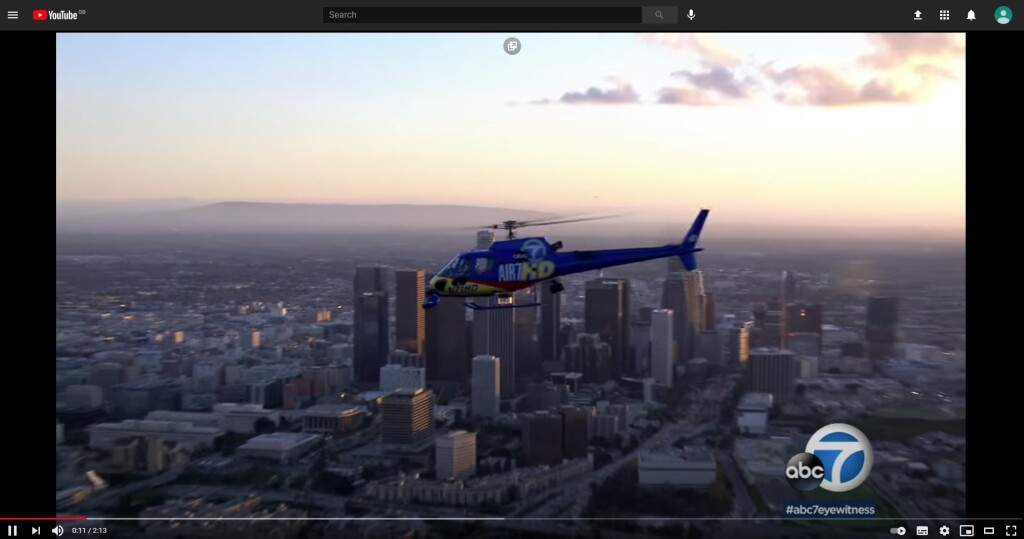
On 4 December 2019 Airbus AS350B2 N71HD was being operated by Helinet Aviation Services as an electronic news-gathering flight for ABC7 News in Los Angeles under Part 91 and visual flight rules, within Class G uncontrolled airspace. The US National Transportation Safety Board (NTSB) explain in their safety investigation report (issued 29 June 2020) that the pilot…
…reported colliding with an unknown object at 1,100 feet above mean sea level (msl) in the vicinity of Los Angeles City Hall. The pilot conducted a precautionary landing at a nearby helipad. Post-flight examination revealed minor damage to the right horizontal stabilizer and tail rotor blade.
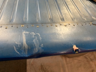
Horizontal Stabaliser Damage on Helinet Aviation Services / ABC7 News AS350B2 ENG Helicopter Over LA City Hall (Credit: NTSB)
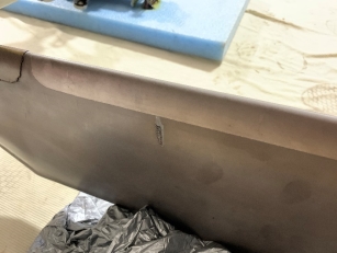
Tail Rotor Blade Damage to Helinet Aviation Services / ABC7 News AS350B2 ENG Helicopter Over LA City Hall (Credit: NTSB)
The helicopter was equipped with a SpiderTrax [sic] flight following system, which indicated the helicopter passing northeasterly in the vicinity of LA City Hall at 7:15 pm at 1,104 feet msl (approximately 828 above ground level (agl)). The pilot and operator reported that no visible evidence of a bird strike was apparent, and believed that the aircraft collided with a small unmanned aircraft (sUAS, or drone).
The three occupants were uninjured.
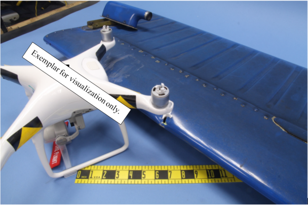
There was a small round dent which partially punctured the leading edge of the horizontal stabilizer. Further dents and scuff marks were approximately 6 to 8 inches outboard of the round dent on the leading edge and along the upper surface. One of the tail rotor blades exhibited a small gouge in the composite surface approximately mid-chord. The horizontal stabilizer and tail rotor were sent to the NTSB Materials Laboratory for examination. Visual examination was consistent with an inflight hard-body impact. The dent and scuff marks were compared to the dimensions of common small drones and were consistent with the distance and orientation between the motor and center fuselage/battery compartment.
“Angled view comparing common drone to impact marks. The drone in the photo is an exemplar of a popular drone used to illustrate size comparison. Numerous manufacturers and models of drone fall into this size class. Does not necessarily depict the actual collision object ” (Credit: NTSB)
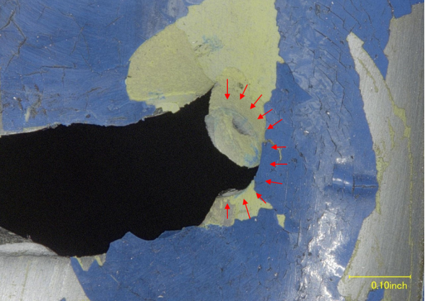
Ultraviolet light inspection revealed no evidence of biological material. The dented region exhibiting material transfer was examined using Fourier-transform infrared spectroscopy (FTIR). The white and gray areas were probed, and the data were contrasted with an area of the painted stabilizer skin surface away from the impact zone. In subtracting out the spectrum peaks from the control area away from the impact zone, several peaks consistent with a different or foreign material were noted. These peaks were consistent with a polycarbonate polymer. Examination of an exemplar popular drone indicated the primary construction material is polycarbonate. (Polycarbonate plastics are used in many other common items, such as safety glasses or light lenses). Under magnification, inside the round dent, a small circular indentation was noted of approximately 0.125 inches (~3 mm) in diameter, exhibiting tears and cracking around its circumference.
Close Up of Damage to Helinet Aviation Services / ABC7 News AS350B2 ENG Helicopter Over LA City Hall (Credit: NTSB)
These features were consistent with fore-to-aft impact with a hard, cylindrical object. The propeller shafts on many common small drones are approximately 3 mm in diameter. The damaged portion of the horizontal stabilizer was sent to the National Institute for Aeronautical Research (NIAR) impact dynamics lab (part of the FAA UAS Center for Excellence). NIAR scanned the damaged component and created a finite element model (FEM) of the stabilizer. The FEM was entered into their impact kinematics simulation with a representative model of a common small drone. The resultant damage was similar to that of the incident, although the calculated relative speeds were higher than those reported by the helicopter pilot. NIAR researchers noted that the collision model they used was of one specific small drone – different construction materials or mass of the colliding object could account for the difference. A small contribution from rotor wash could also contribute.
No evidence was found of a missing drone however.
The operator reported that the onboard cameras were stowed and did not record video at the time of the reported collision. The operator and NTSB investigator conducted a search of social media for any possible indications of a lost drone in the area, nothing definitive was found. Two drone detection companies were operating in the area, but did not have any targets in the area at the time of the report. Both companies reported less than complete coverage of the area.
Previous occurrences:
At the time of this report, the NTSB has gathered information on two other reported collisions in which evidence was consistent with an inflight collision with an sUAS.
Kauai Napali Coast, Hawaii, February 9, 2018: On February 9, 2018, at 14:30 Hawaiian standard time, the pilot of an Airbus EC130-B4 helicopter, N11QK, reported striking a small unmanned aircraft while conducting an air tour in the vicinity of Nu’alolo Kai, on the Kauai Napali Coast, at 2,900 feet mean sea level (msl). Visual flight rules conditions prevailed. There were no injuries to the pilot or six passengers. Three small scratch marks were evident on the right side door of the helicopter. The pilot reported that as the helicopter was descending in a right turn near a canyon and hiking trail, he noticed a drone to his left. He continued the right turn to avoid it, then began to turn back in a continuing descent toward the ocean when a another drone struck the right side of the helicopter. He assessed that the helicopter was handling normally, and continued the tour flight with no incident. Law enforcement was notified. Swabs of the scratched area were examined for organic residue, none was found. In discussion with the tour operator and local law enforcement, it was recognized that the Nu’alolo Kai hiking trail is very popular with drone operators and drones are often seen in the area. The airspace is Class G, with steep rugged terrain.
Aurora, Oregon, May 29, 2018: On May 29, 2018, at 18:55 pacific daylight time, the pilot of a Cessna 170, N3193A, reported that he struck a small unmanned aircraft while enroute at 2,000 feet near the Aurora State Airport (KUAO), Aurora, Oregon. The pilot continued the flight to Kent, Washington, and landed with no further incident. The airplane exhibited a small round dent in the leading edge of the right wingtip fairing, and a concave dent in the outer leading edge of the wing. No drones were found by the FAA or Aurora Airport and other local authorities. The wingtip was examined at the NTSB Materials Laboratory. The dent exhibited characteristics of hard body impact damage and there was no organic residue. An FEM of the wingtip was developed by the NIAR laboratory and put into the impact dynamics simulation with a representative model of a common small drone. The modeling resulted in damage consistent with the physical evidence at normal cruise speeds for a Cessna 170.
NTSB Probable Cause
An inflight collision with a hard object of polycarbonate construction, with size and features consistent with that of a small UAS (drone).
UPDATE 3 July 2020: Near miss with drone, crash on turnpike heightens stress on law enforcement: Video shows the drone blown away by police helicopter downwash in Tulsa, OK.
UPDATE 7 July 2020: AIN News – NTSB: Los Angeles Newscopter Hit Drone
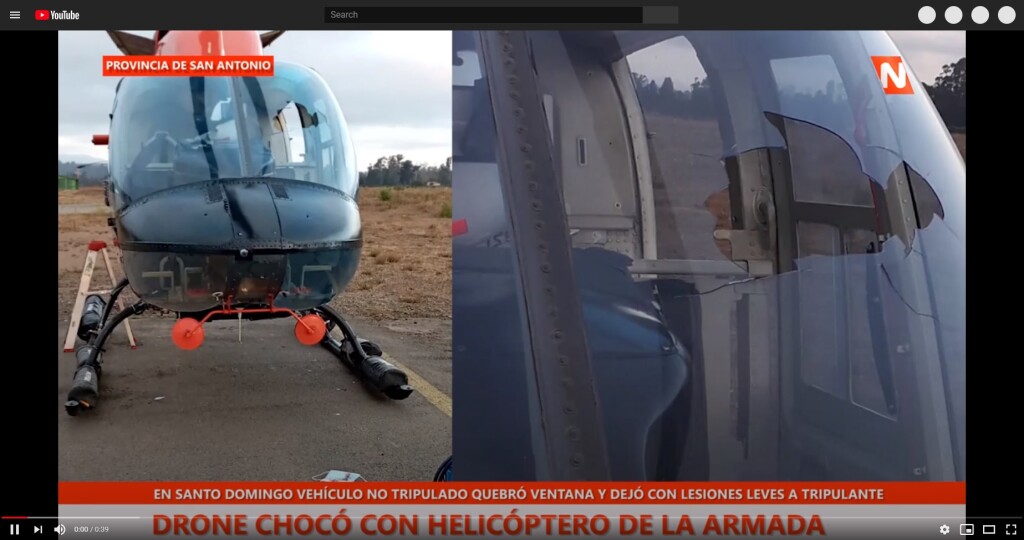
UPDATE 24 January 2021: A Chilean Navy Bell 206B3 / UH-57B struck a 0.57 kg DJI Mavic Air 2 drone on 23 January 2021 and suffered a windscreen penetration and occupant injury (see video).
Helicopter / Drone Mid Air Collision Filming Off-Road Race
UPDATE 5 November 2022: Suspected Drone Strike on Helicopter

Recent Comments