Image Just as Mavic 2 UAS and AS350BA N611TC Collide (Credit: via NTSB)
The King of the Hammers event is part of the Ultra4 Racing series. The event production company, Hammerking Productions Inc, outsource the management of the video production to a contractor. Its that organisation that then hires in helicopter and UAS operators. The NTSB note that:
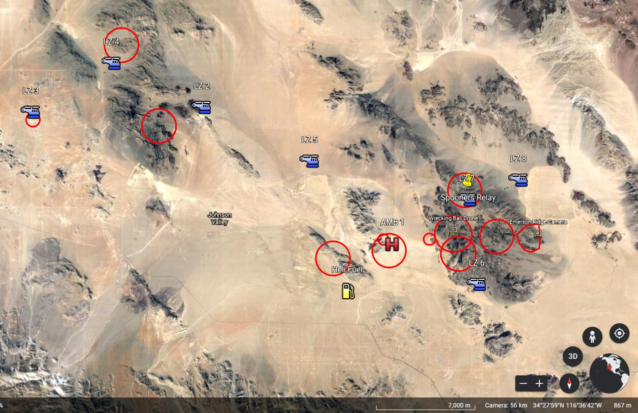
Five helicopters and four drones were contracted to cover the event.
The incident helicopter was operated under Part 91 with an FAA Certificate of Authorization or Waiver to 14 CFR 91.119(b) and (c) for low altitude TV and motion picture filming. The helicopter pilot had 4200 hours of experience including 10 years filming similar events (which suggests the age listed in the NTSB report [20] is incorrect)
The incident drone had been leased by the production company from Lens Rentals and was being operated under a “verbal contract” by a 44 year old individual under Part 107 regulations. They had gained their FAA Remote Pilot Certificate in February 2019 and had 90 hours of experience. The NTSB explain that:
Event organizers provided pre-race information to the helicopter pilots which included…the flight times and schedule for the race, insurance information, procedures for clearing the course of unauthorized persons, and helicopter landing zones and radio frequencies. They provided a Google Earth kmz map including details of the course and locations [too].
According to race management, the locations of the drones indicated on the map were not containment zones but were meant as an indication of the locations where they would have network connection to transmit the video feed.
Organizers stated the drones were limited to less than 400 feet (note: this is in accordance with 14 CFR Part 107) and helicopters were required to remain above 500 feet in areas of spectators (note: this is generally in accordance with 14 CFR Part 91).
The area of the collision was not accessible by spectators.
A pilot meeting was held on February 2, including helicopter pilots and event management. It did not include the drone pilots.
The NTSB report the incident drone pilot (or Remote Pilot-In-Charge [RPIC]) “did not have any operating manuals or checklists for the operation”. They also told the NTSB that, unlike the helicopter pilots, they were not given any event maps.
The incident pilots were not in communication with each other, nor was there any provision or requirement to do so. The helicopter pilots covering the course communicated with each other via a common air-to-air frequency. The drone pilots did not use or monitor radio communications.
The NTSB recount that:
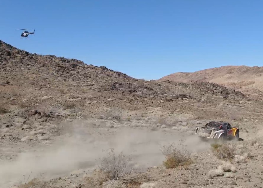
Video from the drone, and the accounts of each pilot, indicate the two aircraft were following a vehicle climbing an undulating dirt track in hilly canyon terrain. Video showed the helicopter visible in the drone camera (which was displayed on the drone pilot’s screen) above and to the right of the drone.
Mavic 2 UAS and AS350BA N611TC Filming {Credit: via NTSB)
The drone continued to follow the vehicle toward the position of the helicopter. As the track turned to the right, the helicopter passed to the left of the frame and out of view beyond a small rise. The track of the vehicle began to turn to the left around the small rise, when the collision occurred.
The drone pilot (RPIC) reported his altitude was about 30 feet above ground, and that he was aware that the incident helicopter as well as others were in the area. The RPIC was operating alone, he did not have a visual observer assisting.
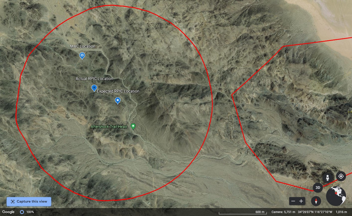
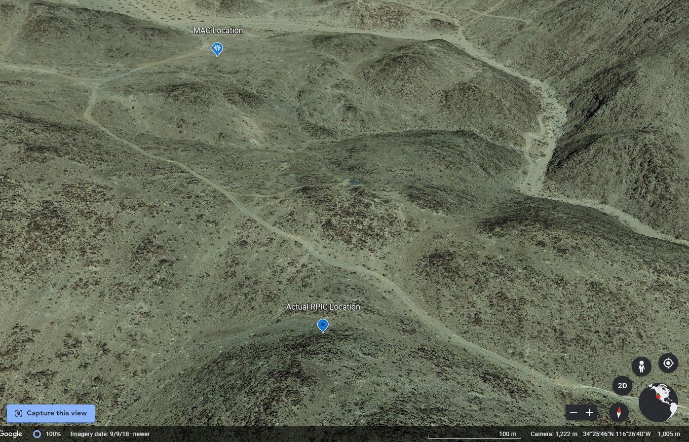
According to a map provided by race organizers, the intended position of the RPIC was about 2,300 feet from where the collision occurred. Both the RPIC and the helicopter pilot provided maps indicating the RPIC was about 1,000 feet west, closer to the collision point.
The helicopter pilot reported that he had seen the drone earlier and flown away. On the incident lap, the helicopter pilot reported that it “popped up” in his line of sight and he flew up course. He flew back toward the course assuming that he was far enough away from where he previously saw the drone when the collision occurred.
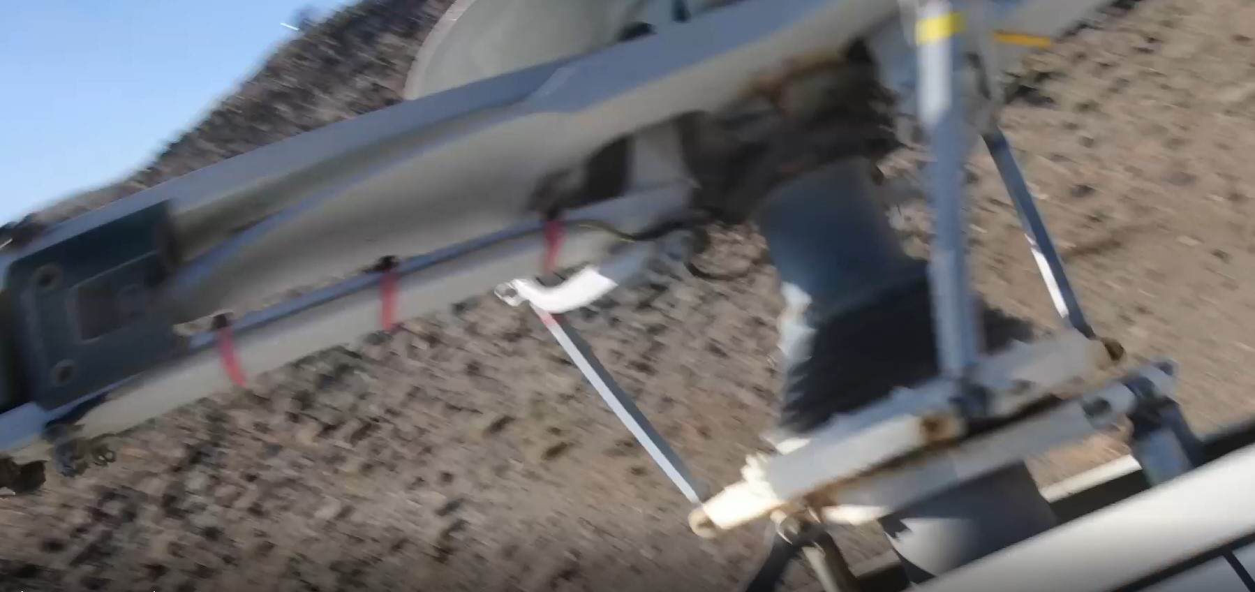
After impact the drone passed the main rotor head of the AS350 before falling away:
In their accident report form submission the drone pilot provided their own reflective analysis and safety recommendations:
The way both drone and helicopters are used to cover this event is very unique. The drone technology in place to cover the canyons and hard to reach areas is especially cutting edge. In the future I will require the guidelines below to be in place at an event/situation like this where both helicopters and drones are used in the same location:
1) Map Provided To All Pilots, Manned and Unmanned: A map highlighting the locations of the drones in the field provided to all pilots (manned or remote). This will let the helicopter pilots know to stay above 500 feet in these certain areas and give them the confidence to know there is no traffic in other locations
2) Meetings: Daily meeting between all pilots discussing each day and what to expect the next. This could be done by Skype or even text but clear collaboration is necessary.
3) Spotter for drone pilots: While FAA only requires a spotter if flying fpv a spotter would be a huge help. Flying at low elevation shooting video is very challenging and background noise sometimes masks an approaching helicopter hard to hear. A spotter when shooting an events where both drones and helicopters are in use would be invaluable.
The NTSB, in common with most rotorcraft and general aviation accidents, unhelpfully make no safety recommendations nor emphasise the drone pilot’s own safety learning from the incident.
The NTSB Probable Cause was, as usual, less a cause and more a statement of the circumstances of the mid air collision: the failure of the small UAS remote pilot to give way to the helicopter, resulting in an inflight collision.
They go on to say: Contributing to the incident was the sUAS remote pilot’s failure to assess and mitigate the risks of operations in close proximity to other aircraft. Also contributing to the incident was the lack of inclusion of the sUAS operations as a part of the aviation activity and risk mitigation.
Again, this is unhelpful as it starts with an old-view of safety concentrating on an individual before a belated mention of the ‘system’ (the coordination of multiple resources during the race).
No mention is made of the height above ground the helicopter was operating.
Aerossurance has worked on several trials and projects where manned and unmanned assets have been used concurrently in a safe and coordinated manner.
Aerossurance has extensive air safety, operations, UAS/UAV/RPAS/Drones, airworthiness, human factors, aviation regulation and safety analysis experience. For practical aviation advice you can trust, contact us at: enquiries@aerossurance.com