Drone Goes Walkabout: Hemispherical Human Factors Hiccup
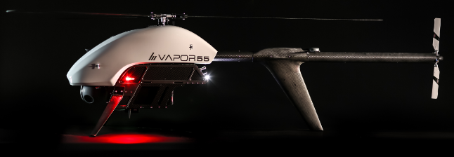
On 27 September 2016, a 55lb / 25kg Pulse Aerospace Vapor 55 Remotely Piloted Air System (RPAS) / Unmanned Air System (UAS) or ‘drone’ helicopter, suffered a Loss of Control (LOC) was operating a trial flight at Lighthouse Beach, Ballina, NSW.
The RPAS helicopter had been operating in manual mode for about 7 minutes when the data link was lost. According to the Australian Transport Safety Bureau (ATSB) investigation report:
Thirty seconds later, the RPA entered the ‘home’ flight mode, and commenced tracking to the programmed home position at an altitude of 154 ft. …the RPA did not respond to the control inputs made by the pilot, and the pilot subsequently lost sight of the RPA. The RPA was not found despite an extensive search.
The Safety Investigation
The cause of the lost signal was not determined. The operator suspected interference from a media outside broadcast unit located about 30 m from the GCS. However, this used a narrow satellite communications uplink. The subsequent disappearance of the RPA was due to errors in flight planning. The ATSB say:
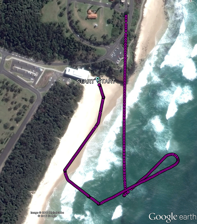
Prior to the flight, the pilot’s preparation for the planned mission involved using Google earth on a computer (not the [Ground Control Station] GCS), and selecting a north-western and a south-eastern reference point. These markers defined an outer rectangle, within which the flight was to take place.
The pilot then transferred an image…onto the GCS using a USB stick…to create the ‘Lighthouse Beach’ mission. To georeference the image, the pilot then overlaid the markers in the image with a point icon on the controller, and entered the latitude and longitude of two positions into the dialogue box on the GCS. Once the image had been georeferenced, the pilot then used the graphical interface to place the start and home icons and any intervening waypoints for the planned mission.
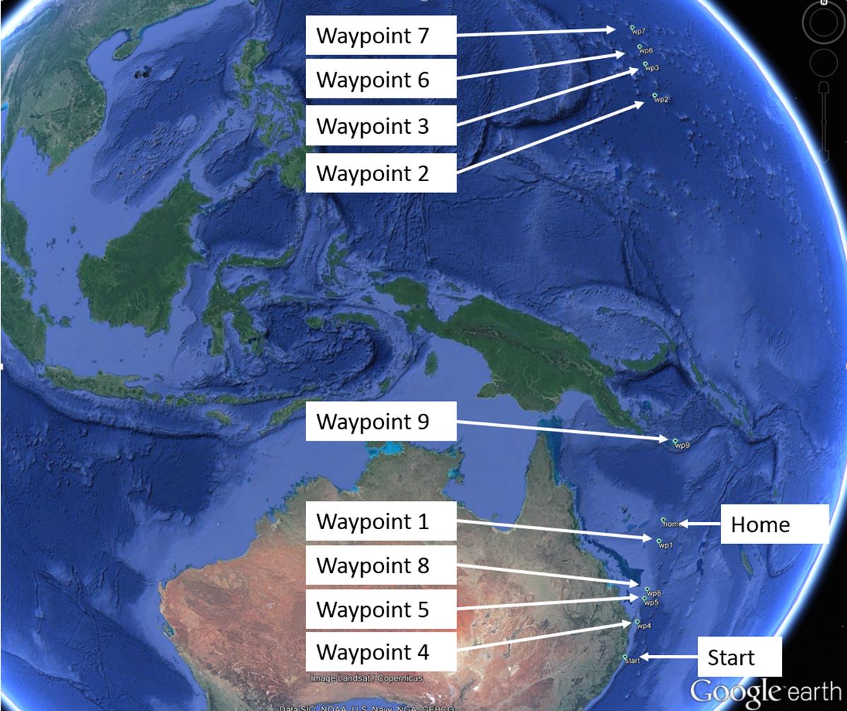
The remote pilot reported that both they and an observer checked each waypoint before the flight, verifying latitude, longitude, altitude and height. However, the GCS data shows that during the planning phase, while the north-western marker was correctly assigned, the south-eastern marker was incorrectly assigned to a georeference point with a latitude in the northern hemisphere. This resulted in all of the waypoints and home location being incorrect, as they were created by dragging icons on the georeferenced image. Waypoints 2, 3, 6 and 7 had latitudes in the northern hemisphere, and the home position was assigned to 17.222395° S and 153.591582° E. That location was in the Coral Sea Islands about 1,200 km north of the start position.
The ATSB say:
The GCS has a ‘flight plan’ tab, which shows the planned distance and time (among other items) for the mission, which could have alerted the pilot to the incorrect latitude references. However, a check of the flight plan tab had not been included in the operator’s pre-flight procedures. In addition, the flight plan tab includes a measure tool that can be used to check that the map size is correct. The manufacturer advised that the following steps are included in their pre-flight procedure specified in the aircraft flight manual:
- verify flight plans
- verify lost communication home waypoint.
The operator stated that there was no further detail of the verification process in the manual. The default hemisphere was north (N) in the GCS for entering positions. The manufacturer stated that there was no feature that would change the default (to south (S)). The manufacturer assessed that changing the default could lead to issues with the conduct of appropriate pre-flight checks. The operator reported that information about the default setting to north was not provided in the Aircraft Flight Manual.
Safety Actions
The RPAS manufacturer advised the ATSB that they are taking the following safety actions:
- Audit of training curriculum to ensure that pilots understand how to verify GPS coordinates, interpret their values and signs. The training course will continue to train pilots on the tools available to them within, and outside of the GCS software.
- Share this incident with operator trainers so that new operators can learn from the events of this incident.
- Continued education and outreach discussions with RPAS operators pertaining to decreased mishap rates through training and currency policies.
The operator advised the ATSB that they are taking these actions:
- The pre-launch checklists have been modified to include additional and enhanced procedures to verify data input and flight plans.
- Investigate the fitting of either GPS or cellular tracking devices to remotely piloted aircraft.
- Update the risk assessment form to include location of external broadcast stations such as television outside broadcast units.
- Brief all company pilots on the event for safety and education purposes.
- Continue liaison with the manufacturer.
ATSB Safety Message
Incorrect reference data can have potentially serious consequences in remotely piloted and manned aircraft. It is imperative that remotely piloted aircraft systems incorporate means of minimising the opportunity for errors to occur and also for detecting and correcting errors that do occur.
The careful application of operational controls and procedures, underpinned by robust risk assessment, will become increasingly important as relevant technologies develop further and new RPA applications continue to emerge. RPA operators should expect data loss events and prepare for these appropriately.
The ATSB has previously highlighted the safety issue of data input errors. Aerossurance has previously discussed the EASA Drone Safety Risk Portfolio and Analysis and the risk to manned helicopters of drone strikes.
UPDATE 16 March 2017: ATSB releases drone safety research report:
The report finds the number of encounters is increasing. While there have been no reported collisions between RPAS and manned aircraft in Australia, and given the variables, the potential consequences of collisions are not yet fully understood.
About half of the 180 occurrences from 2012 to 2016 involved proximity encounters with manned aircraft. Over 60 per cent of all reported RPAS encounters (108 occurrences) occurred in 2016 (69 occurrences).
ATSB Chief Commissioner Greg Hood said: “We expect there could be a doubling in the number of RPAS in Australia by the end of 2017. Based on our knowledge of birdstrikes, RPAS collisions with high capacity air transport aircraft could lead to an engine ingestion in about eight per cent of strikes. RPAS also have the potential to damage a general aviation aircraft’s flight surfaces (wings and tail), which could result in a loss of control. Similar to the impact from a large bird, collision between a RPAS and a general aviation aircraft’s windscreen poses a high risk of penetration.”
UPDATE 1o August 2017: This ATSB RPAS research report has now been updated to the end on June 2017.
UPDATE 19 January 2019: Software Bug and High Winds Down Drone
UPDATE 28 August 2019: Drone Operation Injury: NTSB examine an injury caused after the loss of control of a UAS during a university demonstration.
UPDATE 12 January 2021: Inspection UAS Collides with PNG LNG Export Jetty
UPDATE 12 April 2021: USAF MQ-9A Reaper Lever Confusion: Human Factors
UPDATE 2 June 2021: Drone Pilot Injured in US Prison Geo-fence Incident
UPDATE 4 August 2022: Schiebel Camcopter S-100 Engine Failure Results in Baltic Crash
Aerossurance was pleased to sponsor the 2017 European Society of Air Safety Investigators (ESASI) 8th Regional Seminar in Ljubljana, Slovenia on 19 and 20 April 2017. ESASI is the European chapter of the International Society of Air Safety Investigators (ISASI).
Aerossurance is pleased to be supporting the annual Chartered Institute of Ergonomics & Human Factors’ (CIEHF) Human Factors in Aviation Safety Conference for the third year running. We will be presenting for the second year running too. This year the conference takes place 13 to 14 November 2017 at the Hilton London Gatwick Airport, UK with the theme: How do we improve human performance in today’s aviation business?