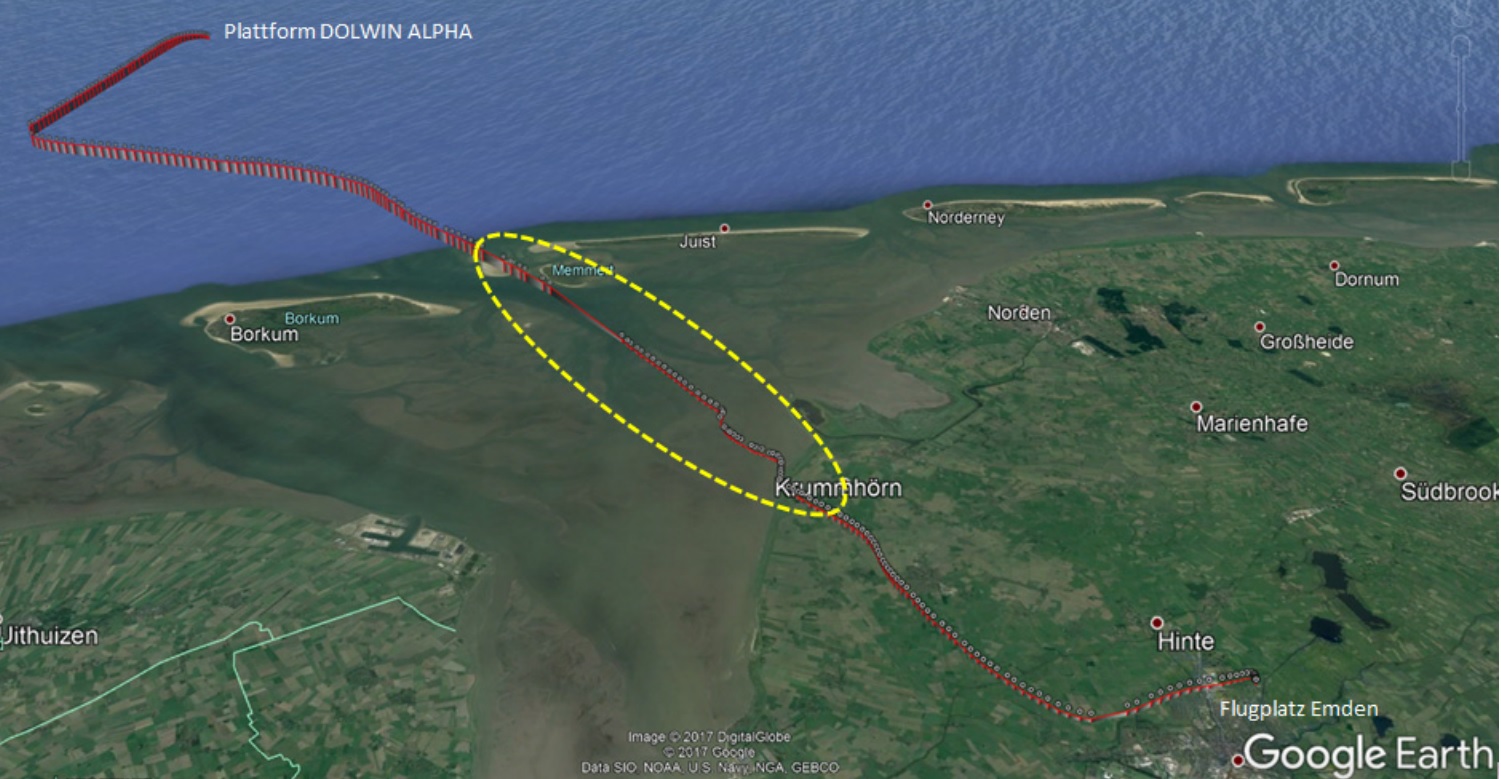
In an interim report they describe that the flight was on a return to Emden from the DolWin Alpha High Voltade Direct Current (HVDC) platform in the North Sea, which helps transit power from offshore wind farms ashore.
At 0842 hrs the helicopter took off now with four persons on board [2 crew. 2 passengers] for the return flight…[and]…climbed to 2,000 ft AMSL which remained the same up until right abeam of Borkum Island. At 0854 hrs the flight crew established radio contact with the Flugleiter at [the uncontrolled] Emden Airfield and requested information regarding the prevailing weather conditions.
They were told:
“Right now it is raining, cloud base few one thousand, overcast thousand five hundred and wind south-west 10 to 15 gusts 20 kt, QNH 1,010 and visibility here visual reference point 2.5 to 3 km.” At 0857 hrs the crew informed Bremen Radar of passing way-point JUIST.
However:
Before reaching way-point JUIST the helicopter began to descend. The descent ended in low altitude with reduced speed near the coast line.
S-76B Flight Profile (Credit: BFU)
Then the helicopter climbed again to about 500 ft AMSL and continued the flight to Emden. At 0901 hrs the crew again requested information regarding the prevailing weather at Emden Airfield.
They were told:
“Right now it has decreased a little bit few seven hundred, broken one thousand, overcast one thousand eight hundred, the rain is gradually slowing down”.
The aircraft landed safely at 0911 hrs. The Aircraft Commander (PIC) had a total flying experience of 11,461 hours, of which 3,025 hours were on type. The First Officer (co-pilot) had 910 hours flying experience, of which 359 hours were on type.
Investigation (Interim Report)
The BFU examined the events leading to the period between 0957 and 0901 when the aircraft lost speed and altitude over the Wadden Sea, the tidal mud flats between the outer island and the mainland.
…during the two legs (outbound and return) the co-pilot in the left-hand seat acted as Pilot Flying (PF) and the Pilot in Command (PIC) in the right-hand seat as Pilot Non Flying (PNF). After take-off from the converter station DOLWIN ALPHA the helicopter had been operated using the Flight Director (FD) coupled in the Upper Modes ALT and NAV. Between the way-points UTIRA and HW751 the FD had decoupled without reason. The two autopilots had changed from Attitude Retention (ATT) Mode to Stability Augmentation System (SAS) Mode. This resulted in the PF having to actively control the helicopter manually. Subsequently, the PNF tried to find and eliminate the cause for the FD failure. Both in vain. After they had enquired about the prevailing weather conditions at Emden Airfield they decided to reduce the flight altitude before reaching the coast line. During descent the helicopter had suddenly encountered heavy rain and significantly reduced visibility. At about 500 ft AMSL the co-pilot had handed over controls to the PIC.
Notably:
He had instructed the co-pilot to extend the landing gear because he wanted to be prepared for a possible off-field landing due to the unexpected bad weather. According to the Cockpit Voice Recorder (CVR) recording the PIC allowed the helicopter to continue the descent because no visual contact with the coast line had been established. At that time even in low altitude there was no visual contact with the coast line. At about 0900 hrs the co-pilot said “100 ft GND”. A few seconds later the computer voice from the radar altimeter [Audio Voice Alerting Device (AVAD)] announcing “One Hundred Feet” and an acoustic signal were recorded. There was no verbal comment about the altitude warning. The helicopter continued to descend.
Significantly (emphasis added):
Both pilots looked outside searching for the coast line or a brighter place in the grey clouds ahead of them. The co-pilot recognised the low altitude and read the radar altimeter “20 ft GND“. He advised the PF accordingly. At the same time the airspeed had decreased to approximately 40 kt. The PF stopped the descent and increased the airspeed. A short time later in low altitude the pilots had the coast line in sight. The flight was continued towards Emden under Visual Flight Rules (VFR) with reduced cruise speed and in low altitude. Due to the limited visibility and low clouds it was decided to fly an approach to runway 07. When the engines were shut off the pilots noticed that the cyclic stick trim switch was not pushed in, i.e. the function was disengaged. The PIC stated that the heavy shower and the therefore reduced visibility had occurred totally unexpectedly. He had not considered to changing flight rules and conducting the instrument approach RNAV (GPS) Y RWY25 to Emden due to the unclear situation with the FD.
Flight Data Recorder (FDR) data was not available to the investigators as the FDR was faulty. They do have radar and Flightradar 24 data. The two passengers, who were facing aft were interviewed:
Then the helicopter had descended in stages until the main rotor generated spray. The passenger estimated the lowest altitude was 5 to 10 m. At the same time the helicopter had had a nose-up attitude. Then the coast line had been reached and they had flown over land slightly above the wind turbines to Emden.
The BFU explain that:
The helicopter was equipped with a Honeywell SPZ -7000 Digital Automatic Flight Control System (DAFCS). This system consists of an autopilot function for attitude stabilisation (SAS or ATT modes), and a flight director function for roll and yaw control (ALT, IAS, VS, HDG, Nav or ILS modes). During automatic flight control one or several flight director modes (upper modes) are coupled with the autopilot in ATT mode. If the cyclic stick trim function is disengaged the AP changes from ATT mode to SAS mode. It is not possible to couple the FD in SAS mode. Prior to departure the DAFCS has to be self-tested with a two-level test (Level 1 and Level 2) with running engines. The crew stated that at the day of the occurrence the two test levels had been without fault. [Additionally] the helicopter was equipped with a Flight Management System (FMS) Universal UNS 1K and a fixed installation Garmin GPS 500W with Moving Map indication. [At Emden] both runway directions (07 and 25) are equipped with RNAV (GPS) and instrument approach and departure procedures. For helicopters approaching from the north way-point JUIST is the Initial Approach Fix (IAF) for RNAV (GPS) Y RWY 07/25 approaches. [On] the day of the occurrence between 0800 hrs and 1000 hrs three more helicopters and one airplane departed for VFR offshore flights and one helicopter for an IFR offshore flight.
They also note that:
The serious incident occurred at a time where the [operator] was in the midst of reorganisation. It encompassed the postholder positions, the revision of the procedures, the training, and internal reporting. Deployment of the S-76B [by the operator] was only planned until the end of 2017 / or the beginning of 2018. As a result the number of crews for commercial flight operations was reduced to three (three PICs and three co-pilots).
In relation to the wind farm support sector:
Since 2010 with the construction and operation of offshore wind energy convertors a new field of activity has developed for helicopter operators in Germany. In the beginning there were just a few flights, by 2016 the number had increased to about 14,000 per year. Due to the aeronautical regulations and the airspace and procedure specifications these flights have so far essentially been conducted in accordance with Visual Flight Rules (VFR). In the European neighbouring states the offshore flights in connection with oil and gas production are essentially conducted in accordance with Instrument Flight Rules (IFR) due to the unpredictable weather or often marginal visual meteorological conditions. …a way-point and route system including stipulated vertical separation and communications procedures were compiled on the initiative of several operators and in agreement with the Deutsche Flugsicherung (German Air Navigation Services, DFS). Since September 2014 a majority of the offshore companies are committed to adhere to this way-point grid and the procedures. In October 2017 the Deutsche Flugsicherung published the AIP AIC VFR 03/17 Reporting point network and special alerting service for helicopters in the North Sea of the Bremen Flight Information as information and recommendation [only].
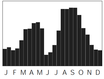
The helicopter had been equipped with an emergency flotation system for Sea State 4 (up to 2.5 m significant wave height). The significant wave height at 0830 hrs at DolWin Alpha was 3.1 m. This would have precluded operations in some countries, such as the UK. The water conditions in the Wadden Sea would have been significantly calmer. Although bird strike risk is not discussed by the BFU, the Wadden Sea is…
…one of the most important wetlands for migratory waterbirds on earth. It provides a rich food supply for 10-12 million birds (2 million geese and ducks, 7 million waders, 2 million gulls and terns), which use the Wadden Sea for moult, wintering and to build up fat reserves before migration to distant breeding and wintering grounds. The majority, approximately 10 million, are migratory birds, which refuel in the Wadden Sea during spring and autumn migration.
Half monthly totals of birds in the Schleswig-Holstein Wadden Sea area (Credit: Schleswig-Holstein Wadden Sea National Park)
BFU Investigation – Final Report Findings (UPDATE 22 November 2019)
The BFU comment on the outbound sector:
The BFU finds it remarkable that right after take-off the helicopter climbed to 2,500 ft AMSL. When taking into account the information from the weather station at Emden Airfield, the precipitation radar image, the minimum visibilities, and the distance to clouds, it is highly unlikely this was possible as VFR flight. According to FlightRadar24 data, with the exception of one helicopter flying in accordance with IFR, all other helicopters and one airplane taking off at Emden Airfield between 0800 and 1000 hrs were flying between 500 ft and 900 ft AMSL
On airspace regulation the BFU made the following findings:
Different airspace actions and national aeronautical regulations existed in the [German] EEZ in the North Sea. In Germany IFR flights in airspace G were not permitted. Instrument approach procedures and so-called Cloud Breaks over sea were not permitted in the FIR Bremen. The route system in the FIR Bremen/Langen was only a voluntary agreement between German companies. It had not been published in the German AIP, with coordinates and procedures, etc. It did not have the status of a route system (including Helicopter Main Routes) as did adjacent FIRs.
On German offshore helicopter operations they comment:
Due to the instrument flight capacity of the helicopters used and the skills and ratings of the pilots, flying in marginal visual meteorological conditions above sea was common and, if necessary, IFR was relied on as back up option. During offshore flights in FIR Bremen/Langen, it was common to climb and descent through cloud layers and fly through clouds for short periods of time. Competition among the German offshore air operators is high and therefore flights are rarely cancelled due to marginal visual meteorological conditions.
On the aircraft BFU conclude:
The deactivation of the stick trim function, a standard function of the DAFCS, resulted in the decoupling of the FD. After the decoupling, the helicopter was still stabilised in the SAS mode by the DAFCS and the so-called command bars were still available to the crew and could have been used for support. Due to the extension of the landing gear, the landing gear warning was suppressed. It is likely that the FDR had been defect quite some time prior to the occurrence. Both pilots stated they had not deleted the CVR. [However] It is highly likely that the CVR recording was deleted intentionally.
In relation to the crew the BFU comment:
Communications between them showed deficiencies concerning mutual support and monitoring which normally characterises the flight-safety improving actions of multi-pilot operation. The attempt to establish ground in sight prior to reaching the coast and the high obstacles located there sporadically was understandable after the helicopter had entered the precipitation area. Contrary to the OM, the descent was not aborted after reaching 500 ft GND. An instrument approach to Emden using RNAV (GPS) Y RWY 25 from JUIST would have been possible; the pilots did not take this into consideration, however. The pilots consciously infringed the low altitude of 100 ft GND in spite of the call-out of the co-pilot and the warning of the AVAD. Both pilots simultaneously attempted to establish visual contact with the coastline and disregarded the monitoring of flight parameters. After the landing, both pilots neglected to file an immediate internal report.
BFU Conclusions (UPDATE 22 November 2019)
Immediate Causes: The helicopter entered precipitation clouds. The cloud base in the precipitation was lower than the helicopter crew had anticipated, Emden Airfield observed, and the Deutscher Wetterdienst forecast. The descent was not stopped in 500 ft GND and an alternative flight conduct not considered. In very low altitude the pilots looked outside and neglected monitoring the instruments. The trust of the less experienced co-pilot in the actions and decisions of the significantly more experienced pilot in command prevented his intervention. The crew did not adhere to the task distribution and mutual monitoring of the operator and the procedures of the flight operations manual regarding the minimum flight altitude.
Contributing Causes: The crew did not recognise the reason for the de-coupling of the flight director. The helicopter, flight altitude, and airspeed had to be controlled manually. The crew did not want to conduct a manual instrument approach to Emden Airfield. The helicopter involved had been exempt from the voluntary, intra-corporate flight data monitoring.
Systemic Causes: In the area of the North Sea it is common that only marginal visual meteorological conditions prevail. In Germany IFR flights in the uncontrolled airspace G are not permitted. The German EEZ is lying below several FIRs with different stipulations and procedures for VFR and IFR flights. Compared with other adjacent FIRs, the Flight Information Region Bremen/Langen did not have special helicopter procedures required by aeronautical regulations. Normally, in FIR Bremen/Langen flights below approximately 1,000 ft AMSL across the North Sea are not monitored by the radar of the air navigation service provider. During offshore flights in FIR Bremen/Langen, it was common to climb and descent through cloud layers and fly through clouds for short periods of time. Up until the end of 2018, flight data monitoring of all off-shore flights was not required by aeronautical regulation.
BFU Safety Recommendation (UPDATE 22 November 2019)
The BFY recommend the Bundesministerium für Verkehr und digitale Infrastruktur (BMVI), the Federal Ministry for Transport and Digital Infrastructure, develop procedures and airspace actions which allow safe flight operations even in marginal weather conditions by day and night offshore.
AAIB Report 7/2008: AS365N G-BLUN “when preparing to land on the North Morecambe platform, in the dark, the helicopter flew past the platform and struck the surface of the sea”.
AAIB Report 1/2011, EC225 G-REDU “the flight crew made a visual approach to the platform during which the helicopter descended and impacted the surface of the sea”.
Aerossurance has extensive air safety, flight operations, SAR, airworthiness, human factors, aviation regulation and safety analysis experience. For practical aviation advice you can trust, contact us at: enquiries@aerossurance.com
The PIC stated that the heavy shower and the therefore reduced visibility had occurred totally unexpectedly. He had not considered to changing flight rules and conducting the instrument approach RNAV (GPS) Y RWY25 to Emden due to the unclear situation with the FD.
In Germany IFR flights in airspace G were not permitted. Instrument approach procedures and so-called Cloud Breaks over sea were not permitted in the FIR Bremen. The route system in the FIR Bremen/Langen was only a voluntary agreement between German companies. It had not been published in the German AIP, with coordinates and procedures, etc. It did not have the status of a route system (including Helicopter Main Routes) as did adjacent FIRs.