Oil & Gas Aerial Survey Aircraft Collided with Communications Tower (Airborne Energy Solutions Cessna 172N C‑GZLU)
On 18 September 2022 Airborne Energy Solutions aerial survey Cessna 172N C‑GZLU, surveying oil and gas pipeline infrastructure, collided with a communications tower near Shaunavon, Saskatchewan (a Controlled Flight Into Terrain [CFIT]). Both pilots onboard died.
The Accident Flight
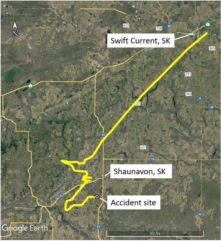
The Transportation Safety Board of Canada (TSB) issued their safety investigation report on 16 May 2023. The TSB explain that the aircraft had departed Swift Current Airport (CYYN), Saskatchewan at 08:27 Local Time and was conducting a visual flight rules (VFR) flight to gather electronic data for a unnamed client along a route that extended southeast of Shaunavon, then eastward to Estevan.
The contract…
…required that there be two pilots on board: one to fly the aircraft, the other to monitor the captured electronic data and assist with navigation duties. The pilots switched seats and duties on alternating flight legs.
The customer’s “job form” for the survey specified a height of 550 feet AGL (±50 feet). The aircraft was equipped with an altimeter, which indicated altitude in feet ASL; however, it was not equipped with, for example, a radio altimeter, to indicate height in feet AGL.
The Pilot Flying, sat in the left seat, held a Commercial Pilot Licence and had 355 hours total flight time, 77 of which were on the C172 for Airborne Energy Solution. The other pilot also held CPL and had 536 hours of total flight time, 529 on type.
However:
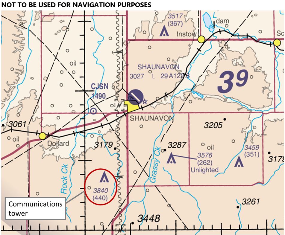
At approximately 1003, the aircraft struck a communications tower approximately 6 an SSW of Shaunavon. The height of the communications tower was 3840 feet ASL, or 440 feet AGL. It was marked and lit in accordance with the Canadian Aviation Regulations. The tower was also depicted on the Regina VFR Navigation Chart.

The aircraft’s last recorded position on its flight tracker (at 1001:30) was 1.2 nm WNW of the communications tower at an altitude of 3741 feet above sea level (ASL), which was 572 feet above ground level (AGL).

The occurrence aircraft was travelling on a track of 88° true (T) when it struck the communications tower approximately 25 feet below the tower’s highest point. A 4-foot section of the aircraft’s right wing was shorn off and was discovered at the base of the tower. The fuselage then travelled approximately 240 m on a track of 174°T, before impacting the ground. A post-impact fire ensued, which consumed most of the remaining fuselage.
TSB note that the…
…area forecast for the occurrence area, valid from 0600, indicated clear sky conditions with visibilities greater than 6 statute miles. Weather was not considered to be a factor in this occurrence.
However:
The sun’s position at the time of the occurrence would have been rising in the east. Solar position calculations indicate that the solar azimuth was 125°T (37° right of the aircraft’s track of 88°T) and the solar elevation was 28° at the time of the collision.
It is possible that glare from the sun obscured the pilot’s view of the communications tower.
TSB Safety Message
Interestingly the treat of glare was not the subject of TSB’s safety message, instead they give the self-evident reminder of…
…the importance of consulting available navigational charts when flight planning and in flight so as to avoid colliding with obstacles identified on those charts.
Our Observations
The TSB report gives no information on the operator’s organisation or supervision, their safety management, crew resource management (CRM), survey, flight planning or training procedures, the survey & flight planning conducted or the charts / chart display technology (if any) aboard.
We would certainly recommend considering sun position when planning surveys.
If the glare prevented the crew identifying the communications tower it would also have reduced the ability to see and avoid other aircraft.
Safety Resources
The European Safety Promotion Network Rotorcraft (ESPN-R) has a helicopter safety discussion group on LinkedIn. You may also find these Aerossurance articles of interest:
- Survey Aircraft Fatal Accident: Fatigue, Fuel Mismanagement and Prior Concerns
- Fatal Snowy Powerline Inspection Flight
- Limitations of See and Avoid: Four Die in HEMS Helicopter / PA-28 Mid Air Collision
- Alpine MAC ANSV Report: Ascending AS350B3 and Descending Jodel D.140E Collided Over Glacier
- How a Cultural Norm Lead to a Fatal C208B Icing Accident
- Running on Fumes: Fatal Canadian Helicopter Accident
- Wait to Weight & Balance – Lessons from a Loss of Control
- Impromptu Flypast Leads to Disaster
- Catastrophe in the Congo – The Company That Lost its Board of Directors
- Wake Turbulence Diamond DA62 Accident in Dubai
- DC3-TP67 CFIT: Result-Oriented Subculture & SMS Shelfware
- Cockpit Tensions and an Automated CFIT Accident
- A Second from Disaster: RNoAF C-130J Near CFIT
- Culture + Non Compliance + Mechanical Failures = DC3 Accident
- Fatal 2019 DC-3 Turbo Prop Accident, Positioning for FAA Flight Test: Power Loss Plus Failure to Feather
- ‘Competitive Behaviour’ and a Fire-Fighting Aircraft Stall
- Disorientated Dive into Lake Erie
- Cessna 208B Collides with C172 after Distraction
- Business Jet Collides With ‘Uncharted’ Obstacle During Go-Around
- Investigators Criticise Cargo Carrier’s Culture & FAA Regulation After Fatal Somatogravic LOC-I
- US Dash 8-100 Stalled and Dropped 5000 ft Over Alaska
- Saab 2000 Descended 900 ft Too Low on Approach to Billund
- Visual Illusions, a Non Standard Approach and Cockpit Gradient: Business Jet Accident at Aarhus
- Double Trouble: Offshore Surveillance P68 Forced to Glide

Recent Comments