Flat Light B206L4 Alaskan CFIT & 11 Hour Emergency Response Delay (Maritime Helicopter, Bell 206L4 M311NH)
On 20 July 2023 Bell 206L4 N311MH of Maritime Helicopters, was destroyed when it impacted the surface of Lake Itinik, c30 miles east of Wainwright, North Slope, Alaska. The pilot and three passengers died. The helicopter was contracted by the Alaska Department of Natural Resources (DNR) to transport scientists to various remote locations.
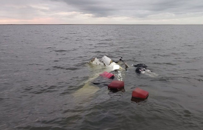
Wreckage of Maritime Helicopters Bell 206L4 N311MH in Lake Itinik, North Slope, Alaska (Credit: NTSB)
The US National Transportation Safety Board (NTSB) published their safety investigation report on 20 August 2025.
The Accident Flight
The NTSB explain the pilot recently retired from the US military and this was his first civil job as a pilot, commencing in October 2022. NTSB state he had about 1,900 hours of flight experience in helicopters, 80 on type, 140 in Alaska. The pilot flew the helicopter from Fairbanks to Utqiagvik (formerly Barrow) two days before the accident flight and had flown the previous day.
On the day of the accident the helicopter departed on a Visual Flight Rules (VFR) flight at c 10:01 Local Time according to data from the aircraft’s Honeywell SkyConnect satellite tracking system, which broadcast every 3 minutes. According to the NTSB:
Management personnel from Maritime Helicopters, as well as personnel from DNR had real-time flight following capabilities of the accident helicopter.
It appears the morning departure had been delayed by fog according to a message to the DNR from one of the passengers. It was on the ground for c10 minutes Atqasuk Airport (PATQ) but the satellite tracking system last received data at 11:04.

Noticeable is the helicopter was never above 266 ft msl. NTSB note that the day before Sky Connect Tracker data for the same pilot and helicopter showed “an average altitude of about 200 ft msl with an average airspeed of about 105 knots”.
No information is provide by NTSB on where the helicopter was heading of what the scientists’ objectives were.
At about 11:12 the Sky Connect system sent out an overdue aircraft report, but that report went
unnoticed by the operator or the DNR.The accident helicopter was expected to return to Utqiagvik by 20:30
The helicopter was reported overdue at 22:30 by an employee of the State of Alaska Geological Survey [part of DNR].
The North Slope Borough (NSB) Search and Rescue (SAR) Sikorsky S-92A was tasked to search for the missing helicopter. NSB have an S-92A and a Bell 412 that are being replaced by two Leonardo AW189s.
The partially submerged, fragmented helicopter wreckage was found in the shallow waters of Lake Itinik…a large, oval-shaped arctic lake more than three miles wide in some areas.
The lake is surrounded by “flat, featureless, arctic tundra“.
The NTSB Safety Investigation
Examination of the wreckage revealed no pre-impact issues with the helicopter.

Wreckage of Maritime Helicopters Bell 206L4 N311MH (Credit: NTSB)
NTSB comment that:
Archived satellite tracking data indicated that the helicopter was flying about 88 ft above ground level (agl) at 93 knots shortly before impacting the water. Although there was a possibility of some overcast clouds and restricted visibility in fog/mist over the accident site, there were no observations or forecasts for any significant turbulence, low-level wind shear, convective activity, or icing over the area at the time of the accident.
However, the NTSB mention:
Due to fiber optic outages, there were a limited number of FAA weather camera images available. There were no images from the closest weather camera (PATQ) facing the accident site (northwest).
They also say:
Another pilot in the area of the accident reported clear skies with no restriction to visibility, and weather camera images near the accident site also revealed no cloud coverage and unrestricted visibility.
The operator challenged the inclusion of the ‘other pilot’s’ comments as there was no detail of where that pilot was and when, and the NTSB also choose to include that pilots judgemental comments on the recorded flight data of the accident aircraft in response to an NTSB question. The operator also challenged the NTSB’s out of context quote of their Director of Operations and from the DNR on permits. In contrast the NTSB did not note that the Director of Operations considered the accident pilot “risk averse” and their had been no adverse feedback from customers on the pilot.
The NTSB note that:
As part of his initial training, the pilot completed an exam on flat-light conditions on October 21, 2022. On a follow up exam, the pilot identified the North Slope as an area conducive to flat light
conditions.
Flat light is a visual condition where a) sunlight is diffused, typically by overcast skies and b) there is flat, featureless terrain, calm water, or snow-covered terrain. These conditions limit a pilot’s ability to discern topographical features and determine aircraft altitude and/or attitude.
In 2024 the Transportation Safety Board of Canada (TSB) published their safety investigation report into the crash of Airbus AS350B2 C-FYDA of Great Slave Helicopters on Griffith Island, Nunavut on 21 April 2021. Flat light was a factor in that accident. We have previously published two relevant helicopter accident case studies:
According to the operator, flat light flight procedures are covered in their training program, and overwater flight procedures are covered in their Standard Operating Procedures (SOP’s).
NTSB observe that the helicopter, which was not fitted with floats…
…was being operated over water below the operator’s requirement of being within power-off gliding distance from shore.
The NTSB’s analysis is:
The pilot’s decision to fly at a low altitude in flat light conditions, which obscured the features of the terrain, likely resulted in a loss of visual clues regarding the helicopter’s distance from the ground. A flat, featureless lake offers little in the way of visual references for the pilot. Without terrain, landmarks, or other visual cues to help judge altitude and position, it’s easy to become disoriented. This can be particularly dangerous when flying at low altitudes. The flat, reflective surface of the water can create a false horizon illusion, making it difficult for the pilot to accurately perceive the aircraft’s attitude. Over a flat, featureless surface like a lake, depth perception can be impaired, making it difficult to judge the distance to the water and increasing the risk of flying too low or contacting the water.
The NTSB conducted toxicology tests that indicated that the pilot had used the over-the-counter antihistamine medication cetirizine.
The FAA states that pilots should wait 48 hours after using cetirizine before flying to allow time for the drug to be cleared from circulation.
The measured level in the blood sample indicated a possibility of…
…impairing effects, such as mild sedation, at the time of the accident. However the investigation was not able to determine what role, if any, the effects of the pilot’s cetirizine use may have had on his operation of the helicopter.
According to the NTSB, the operator’s procedures when an aircraft is “is more than 60 minutes overdue from the latest ETA” OR (as in this case) “an emergency signal is indicated by the aircraft flight following system” is to:
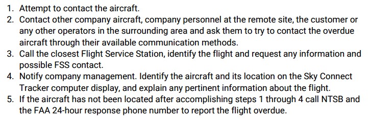
As discussed above, this was not done. However, in the witness transcripts the NTSB asked the operator’s Director of Operations:
Are you in the loop of what the aircraft is doing in any given day?
They responded:
No, the client tracks the aircraft. DNR has better tracking with the inReach devices. [The operator] should have gotten a notification through Honeywell that there was an issue after the accident, but that notification never came.
The latter comment is not followed up by NTSB.
NTSB Probable Cause
The pilot’s decision to fly at a low altitude over a large body of water toward featureless terrain, which resulted in a loss of visual clues and controlled flight into terrain.
No safety recommendations are made.
Our Safety Observations
The NTSB investigation focuses on the low flying, which clearly raised the risk of spatial disorientation and Controlled Flight Into Terrain (CFIT).
While it would not have changed the outcome for the four occupants, the 11 hour delay raising the alarm is disturbing. Its therefore surprising and disappointing that this was not investigated further as both Maritime Helicopters and the DNR continue to be responsible for flight following and/or monitoring that their employees are safe.
Safety Resources
The European Safety Promotion Network Rotorcraft (ESPN-R) has a helicopter safety discussion group on LinkedIn. You may also find these Aerossurance articles of interest:
- Canadian Coast Guard Helicopter Accident: CFIT, Survivability and More
- Canadian Flat Light CFIT
- Japanese Rescue B412 Fatal CFIT
- Antarctic Helicopter Accidents
- Alaskan AS350 CFIT With Unrestrained Cargo in Cabin
- Low Viz Helicopter CFIT Accident, Alaska
- Austrian Police EC135P2+ Impacted Glassy Lake
- Fish Spotting Helicopter Strikes Glassy Sea
- EC135P2 Spatial Disorientation Accident
- HEMS EC135T1 CFIT During Mountain Take Off in Poor Visibility
- HEMS AW109S Collided With Radio Mast During Night Flight
- A Short Flight to Disaster: A109 Mountain CFIT in Marginal Weather
- HEMS Black Hole Accident: “Organisational, Regulatory and Oversight Deficiencies”
- Taiwan NASC UH-60M Night Medevac Helicopter Take Off Accident
- Night Offshore Windfarm HEMS Winch Training CFIT
- RCMP AS350B3 Left Uncovered During Snowfall Fatally Loses Power on Take Off
- EC130B4 Destroyed After Ice Ingestion – Engine Intake Left Uncovered
- Inexperienced IIMC over Chesapeake Bay: Reduced Visual References Require Vigilance
- Italian HEMS AW139 Inadvertent IMC Accident
- Sécurité Civile Fatal EC145 CFIT: Night, Low Ceiling and a Change in Route
- Tragic Texan B206B3 CFIT in Dark Night VMC
- Fatal B206L3 Cell Phone Discount Distracted CFIT
- Windscreen Rain Refraction: Mountain Mine Site HESLO CFIT
- That Others May Live – Inadvertent IMC & The Value of Flight Data Monitoring
- Black Hawk Scud Running in Tennessee: IIMC & CFIT
- Heliski Flat Light Flight into Terrain
- Whiteout During Avalanche Explosive Placement
- Blinded by Light, Spanish Customs AS365 Crashed During Night-time Hot Pursuit
EHEST Leaflet HE 13 Weather Threat For VMC Flights:
Recent Comments