Inexperienced IIMC over Chesapeake Bay: Reduced Visual References Require Vigilance
5 February 2021
Inexperienced IIMC over Chesapeake Bay (Guimbal Cabri G2 N572MD): Reduced Visual References Require Vigilance
Just after noon on 4 May 2019, the privately flown GuimbalCabri G2 helicopter N572MD, was destroyed near Kent Island, Maryland, with the loss of both pilot and passenger, when it impacted the water.
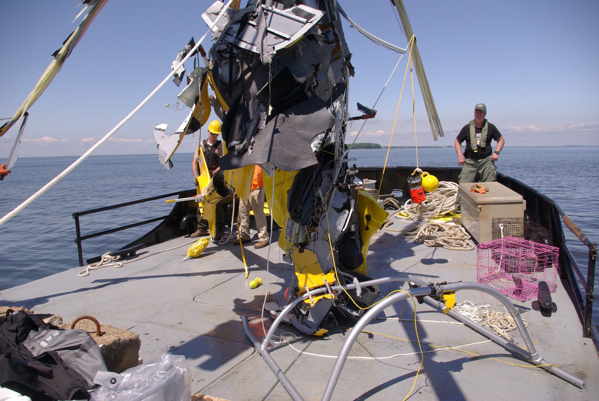
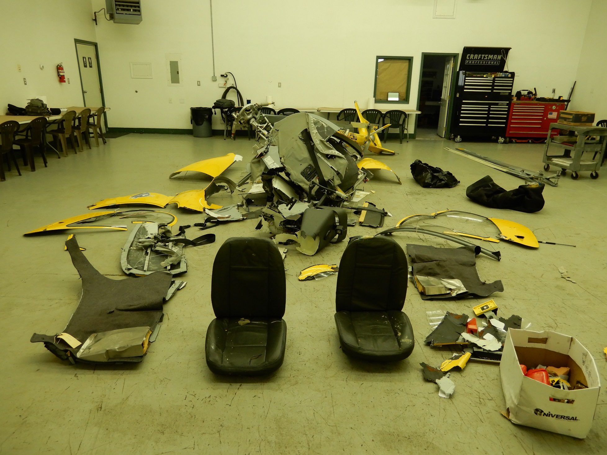
Salvage of Wreckage of Guimbal Cabri G2 N572MD from Chesapeake Bay (Credit: MD Department of Natural Resources via NTSB)
The Accident Flight
The US National Transportation Safety Board (NTSB) explain in their safety investigation report that the flight was planned so the passenger could take photos of a family member’s fishing trip in Chesapeake Bay. The pilot was aged 38 and had just 103.5 hours flight time in total, all in the Cabri G2. He neither held an instrument rating nor undertaken any instrument training. The flight school‘s rental agreement for the aircraft limited flight when flying without a flight instructor to VFR operations with a 3,000-ft ceiling and 6 miles visibility. The Cabri G2 is also not cleared for IFR operations.
The passenger texted the family member at…1036… “The closer you stayed at [sic] Poplar Island the better chance we might have [of] finding you with this low ceiling there’s flight restrictions.”
The National Weather Service issued an update at 1045 for AIRMET Sierra, which indicated IFR conditions for the area surrounding the accident location and advised of ceilings below 1,000 ft, visibility below 3 statute miles, precipitation, mist, and fog.
The pilot called flight services at 1102 to file a special flight rules area (SFRA) flight plan for a local flight originating from Tipton Airport (FME), Fort Meade, Maryland.
During the phone call, the flight briefer noted that instrument meteorological conditions (IMC) prevailed…and that he could not recommend a visual flight rules flight. Furthermore, he stated that AIRMET Sierra was issued for instrument flight rule (IFR) conditions and was currently active and ending between 1700 and 2000. The briefer asked the pilot if he needed a standard weather briefing and the pilot responded that he did not need any other information.
At 1145, the passenger texted…that the helicopter was en route.
At 1151, the family member sent the passenger the GPS location and the passenger responded at 1202, “Rats. You guys are too far west… flight rules.”
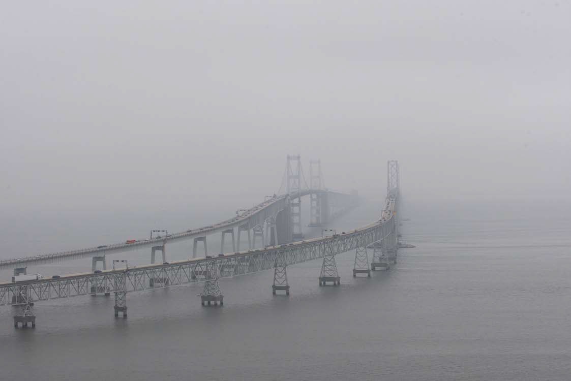
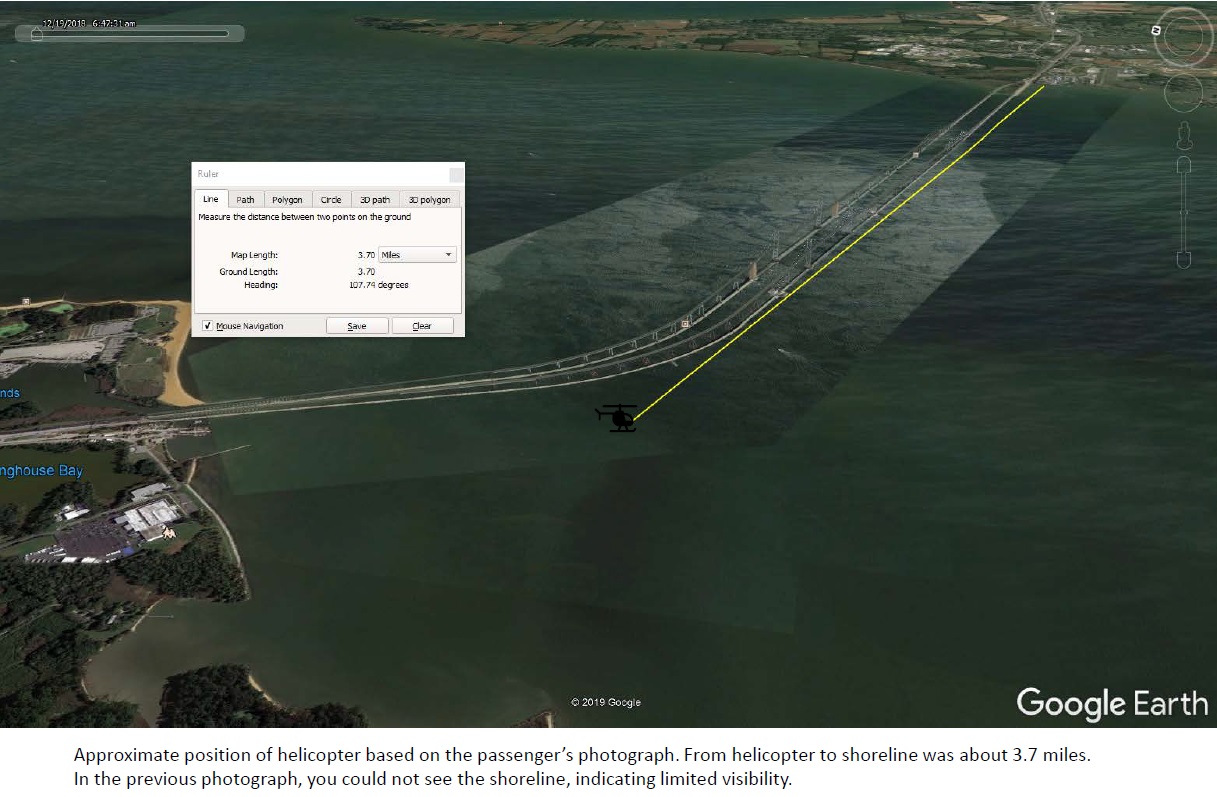
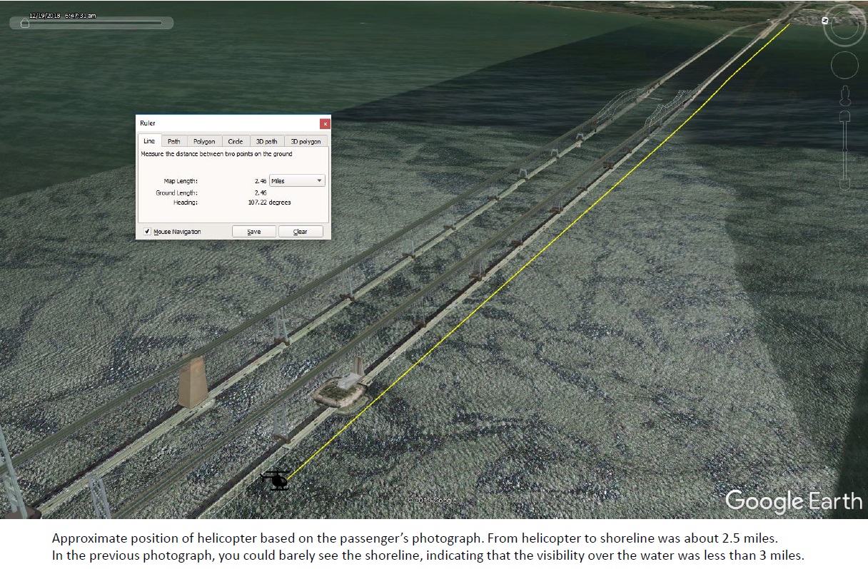
Images taken by the passenger as the helicopter headed east along the Chesapeake Bay Bridge to Kent Island were compared with geographic data and indicate low visibility early in the flight:
Photo from Guimbal Cabri G2 N572MD as it Routed East Alongside the Chesapeake Bay Bridge at 11:52:06 (Credit: Via NTSB)
Photo from Guimbal Cabri G2 N572MD as it Routed East Alongside the Chesapeake Bay Bridge at 11:53:00 (Credit: Via NTSB)
The NTSB don’t comment, but the altitude appears to be around 200-250 ft and the lateral offset perhaps 300 ft.
At 1203 the family member sent another GPS location to the passenger and the passenger responded at 1208, “Can you see us? We are hitting the wall that we can’t fly through.” The family member responded, “not really” and the passenger sent one last text message at 1208 stating, “Give me one more pin to try.” There were no further communications with the passenger.
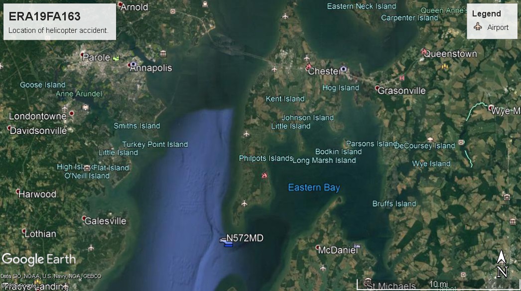
The helicopter impacted the Chesapeake Bay about 1.5 miles from the [southern] shoreline of Kent Island…
The NTSB Safety Investigation
The wreckage was recovered from a 63 ft depth. Examination revealed no evidence of any pre-impact anomalies.
Wreckage of Guimbal Cabri G2 N572MD (Credit: NTSB)
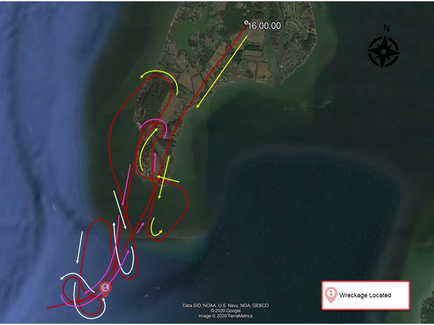
Federal Aviation Administration (FAA) radar data (marked with UTC time – Local +4) shows the helicopter…
….flew over Kent Island and made several left and right turns over the southern tip of the island then flew about 2 miles south of the island.
Guimbal Cabri G2 N572MD Route (Credit: NTSB)
The helicopter manoeuvred in that area beginning at 1200 until radar contact was lost at 1211.
The radar shows the helicopter was flying about 175 ft AMSL for the final 10 minutes of the flight. It was seen by several witnesses. One said the weather was “cloudy and the
fog was heavy.” Another that the helicopter was “flying very low to the water in dense fog.”
The recorded weather at Bay Bridge Airport, Stevensville, Maryland, 8 nm NE, at around the time of the accident was 5 knots wind from 350°, visibility of 3 miles, mist, overcast clouds at 400 ft AGL, temperature 18°C and dew point 18°C.
NTSB Analysis
In these limited visibility conditions, especially when flying away from shore, the pilot’s workload would have increased as he divided his attention between maintaining control of the helicopter and an adequate altitude above the water using poor visual cues and positioning of the helicopter laterally while looking for the fishing vessel.
These conditions were conducive to the both the development of spatial disorientation and loss of control, or an inadvertent descent into the water (due to distraction or a visual illusion).
The ability of the pilot to detect any loss of control or a trajectory towards the water was significantly reduced as a result of the extremely low altitude in which the flight over water was conducted, the low visibility, the lack of instruments on board to allow for instrument flight, and his lack of instrument training and experience.
NTSB Probable Cause
The noninstrument-rated pilot’s continued visual flight into IMC, which resulted in an inadvertent descent into the water.
Contributing…was the pilot’s decision to conduct the flight at a low altitude without sufficient cues to aid in the perception of attitude and altitude.
Our Human Factors Observation
UPDATE 6 February 2021: A number of readers have commented to us along the lines of: “Why did they persist with an aerial photography flight in poor weather?”. We’d suggest this may be a form of Plan Continuation Bias, i.e. the unconscious cognitive bias to continue with the original plan in spite of changing conditions.
About two-thirds of general aviation accidents that occur in reduced visibility weather conditions are fatal. The accidents can involve pilot spatial disorientation or controlled flight into terrain. Even in visual weather conditions, flights at night over areas with limited ground lighting (which provides few visual ground references) can be challenging.
Preflight weather briefings are critical to safe flight. In-flight, weather information can also help pilots make decisions, as can in-cockpit weather equipment that can supplement official information. In cockpit equipment requires an understanding of the features and limitations. We often see pilots who decide to turn back after they have already encountered weather; that is too late.
Pilot’s shouldn’t allow a situation to become dangerous before deciding to act. Additionally, air traffic controllers are there to help; be honest with them about your situation and ask for help. The use of instruments, if pilots are proficient, can also help pilots navigate these challenging areas.
This EHEST leaflet covers various subjects including Degraded Visual Environments (DVEs).
Robinson Safety Notice SN-44 discusses carrying passengers and the responsibilities of a pilot.
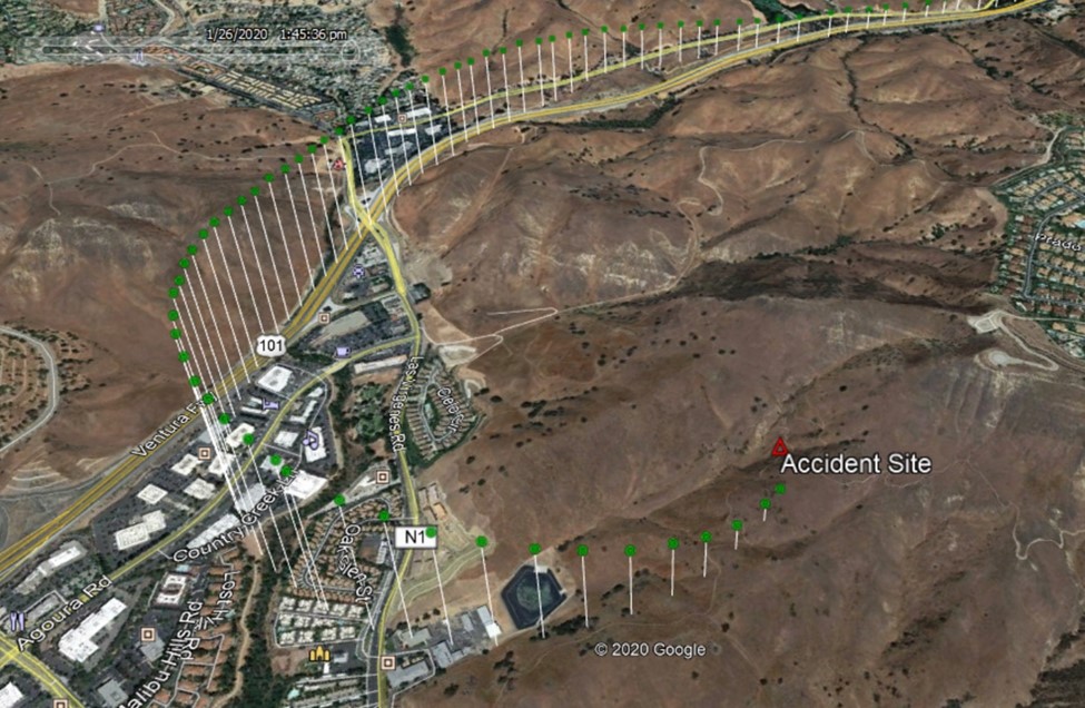
UPDATE 9 February 2021: The NTSB held a board meeting that determined the pilot’s decision to continue VFR flight into IMC, resulting in spatial disorientation and a loss of control, led to the fatal 26 January 2020 crash of a SikorskyS-76B helicopter N72EX in Calabasas, California.
The pilot and eight passengers [including baseball legend Kobe Bryant] died when the helicopter, operated by Island Express Helicopters, Inc., entered a rapidly descending left turn and crashed into terrain.
Contributing to the accident was the pilot’s likely self-induced pressure and plan continuation bias, which adversely affected his decision making. The NTSB also determined Island Express Helicopters Inc.’s inadequate review and oversight of its safety management process contributed to the crash.
“Unfortunately, we continue to see these same issues influence poor decision making among otherwise experienced pilots in aviation crashes,” said NTSB Chairman Robert Sumwalt. “Had this pilot not succumbed to the pressures he placed on himself to continue the flight into adverse weather, it is likely this accident would not have happened. A robust safety management system can help operators like Island Express provide the support their pilots need to help them resist such very real pressures.”
Aerossurance has extensive air safety, operations, SAR, airworthiness, human factors, aviation regulation and safety analysis experience. For practical aviation advice you can trust, contact us at: enquiries@aerossurance.com