Windscreen Rain Refraction: Mountain Mine Site HESLO CFIT
2 April 2021
Windscreen Rain Refraction: Mountain Mine Site HESLO CFIT (Aberdeen Helicopters Airbus AS350B2 C-FAHC)
On 17 August 2020 Airbus HelicoptersAS350B2C-FAHC of Aberdeen Helicopters impacted a mountainside near Eskay Creek Mine, Iskut River, 45 nm from Stewart, British Columbia. This was during Helicopter External Sling Load Operations (HESLO) supporting mineral exploration. The pilot, the sole occupant, died in this Controlled Flight Into Terrain (CFIT) accident. There was also a post crash fire.
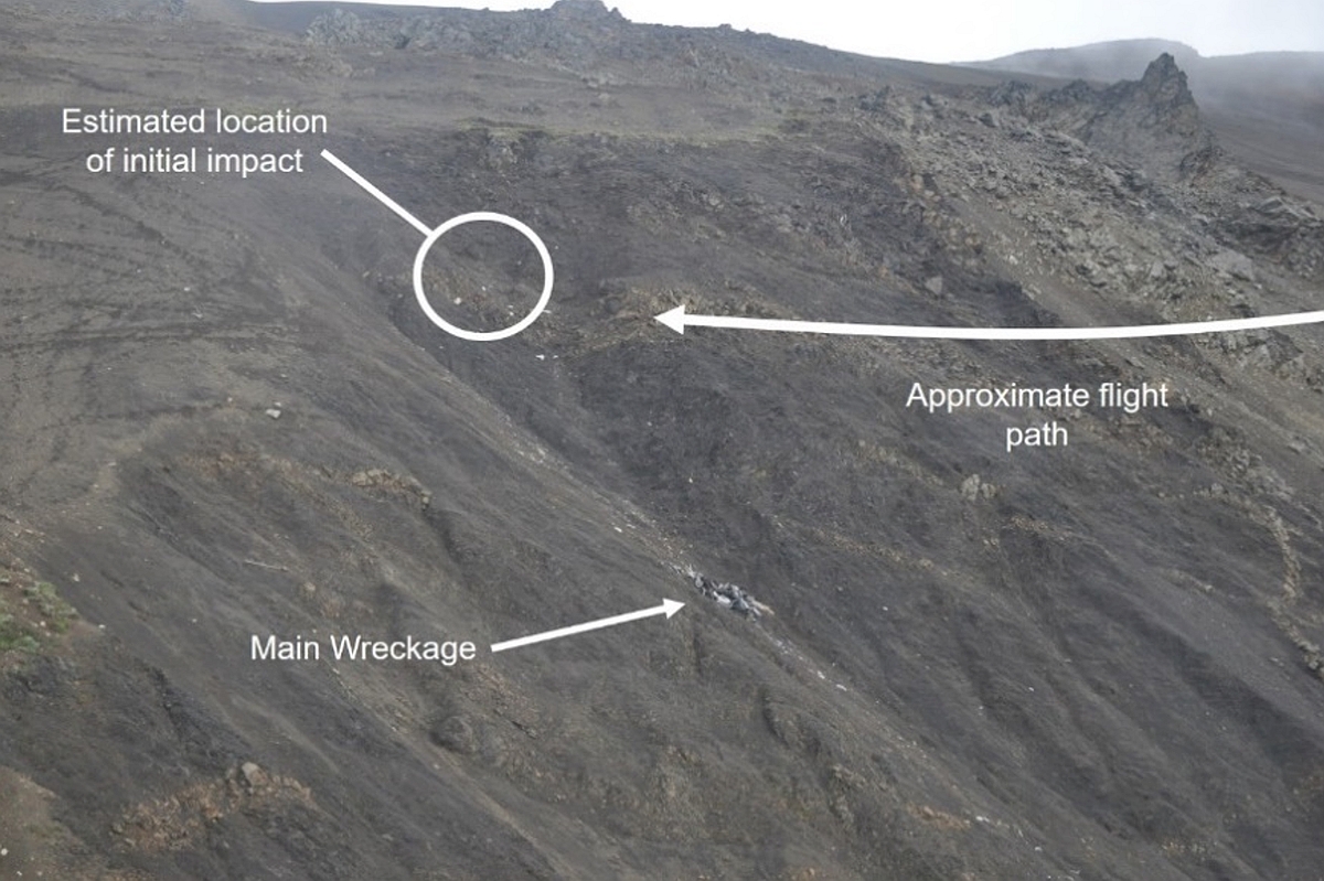
Accident Site: Aberdeen Helicopters Airbus AS350B2 C-FAHC near Eskay Creek Mine, BC (Credit: TSB)
The Accident Flight
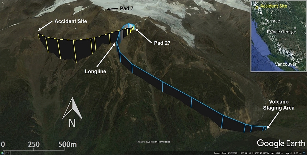
The Transportation Safety Board of Canada (TSB) explain in their safety investigation report (issued 9 March 2021) that the pilot started work at 0652. This was his second summer flying in that area in support of the exploration company. He had 2800 flying hours of experience, 900 on type. His first task was to fly the day shift crew to their drill sites on Nickel Mountain, BC and returning the night shift crew to Garibaldi Camp (located 9 nm from the drilling site). The pilot picked up another two workers from the camp, dropped them off on the mountain, and, at approximately 0750, landed at Pad 27 the Volcano staging area, approximately 1 nm from the drilling site.
The pilot returned to Pad 27 at approximately 0854 to resume the longline operation to move the drill rig. During one of the 11 lifts, the pilot communicated that he would have to hover in place due to reduced visibility before he could continue with the lift. The visibility improved and the rig transfer continued. At approximately 1006, the pilot returned to the Volcano staging area to refuel. At 1022, the pilot returned to Pad 27 to move the last piece of the drill rig. After the drill foreman had hooked the load up to the helicopter’s longline, the pilot communicated that poor weather was approaching and that he was unable to take the load. The load was disconnected and the helicopter hovered in place for approximately 1 minute. At 1024, the pilot backed away from the drill pad downslope (southwestward) at a ground speed of between 1 and 2 knots and stopped approximately 200 feet away. He then moved back toward the pad, and the drill crew asked if they should remove the longline. The pilot said it was not necessary, and at 1025:40, he turned and began to accelerate on a southwestward track. Heavy rain began at this time. Over the next 30 seconds, global positioning system (GPS) data showed that the helicopter continued southwest and accelerated to a ground speed of approximately 70 knots at GPS altitudes of between 5600 feet above sea level (ASL) and 5500 feet ASL. At 1026:02, the pilot released the longline from the helicopter onto the hillside about 800 feet west of Pad 27 and, 9 seconds later, the helicopter began to track to the right in a turn at approximately 5° per second. The change in altitude during this turn was less than 100 feet. The turn continued until just after 1026:27, when the helicopter collided with terrain… at approximately 5500 feet ASL on a steep mountainside.
Flight Path of Aberdeen Helicopters Airbus AS350B2 C-FAHC near Eskay Creek Mine, BC (Credit: TSB)
The damage was consistent with a high-energy impact. Most of the aircraft was consumed by the post-impact fire with the exception of the tail boom and the floorboard area of the cabin.
Emergency Response
When the heavy rain began, the drill crew at Pad 27 sought shelter in the survival shack at the drill site. They emerged after approximately 15 minutes and, assuming the helicopter was waiting at the Volcano staging area, attempted to contact the pilot by radio. The crew at Pad 7 also tried to contact the pilot by radio. Neither crew was successful. The drill crews began a ground search in their immediate areas and, at approximately 1111, an air search began with another Aberdeen helicopter that was in use for the exploration project. The air search focused on likely places the helicopter could have set down to wait out poor weather conditions. After this unsuccessful initial search, the Joint Rescue Coordination Centre (JRCC) in Victoria, BC, was notified at 1236, and a search and rescue aircraft was tasked with the search at 1422. At 1428, the pilot of the other company helicopter, who had begun a patterned search of Nickel Mountain at about 1407, informed the camp that he had located the crash site and that the crash was not survivable. At 1453, the JRCC was informed and the search and rescue aircraft was stood down.
It is not uncommon for helicopter emergency locater transmitters (ELTs) to fail to operate due to damage between ELT and antennae.
The helicopter was equipped with a Kannad 406AF-Compact ELT. The Canadian Mission Control Centre did not receive a signal from the aircraft’s 406 MHz ELT, and no signal was detected by the company’s other helicopter during the search. Due to the nature of the impact and the post-impact fire, it could not be determined why no signal was transmitted.
TSB Safety Investigation
The helicopter was not fitted with any onboard recording devices to assist investigators.
Nothing was found during the post-accident examination to indicate that an airframe failure or system malfunction occurred either before or during the occurrence flight. Based on a review of the pilot’s work and rest schedule, fatigue was not considered a factor. The accident occurred in an area known for rapidly changing weather conditions. This is to be expected in a region where mountainous terrain is directly affected by moist coastal air. Garibaldi Camp had internet connectivity, but it could not be determined whether the pilot had accessed online weather information before the flight.
Overcast weather and precipitation were forecast.
To determine current conditions, the camp routinely contacted the night crews on the mountain each morning to obtain direct weather information. On the morning of the accident, the weather was reported as clear and raining. Clear meant that the drill sites were not obscured by cloud.
TSB Safety Message
VFR flight in reduced visibility conditions, whether they are caused by precipitation or obscuring phenomena, is hazardous, particularly in mountainous terrain. In areas where weather changes rapidly, it is important that pilots and air operators establish operational limits and procedures to maintain visual contact with the terrain at all times.
An error in vision can occur when flying in rain. The presence of rain on the windscreen, in addition to causing poor visibility, introduces a refraction error. This error is because of two things: firstly, the reduced transparency of the rain-covered windscreen causes the eye to see a horizon below the true one (because of the eye response to the relative brightness of the upper bright part and the lower dark part); and secondly, the shape and pattern of the ripples formed on the windscreen, particularly on sloping ones, which cause objects to appear lower. The error may be present as a result of one or other of the two causes, or of both, in which case it is cumulative and is of the order of about 5° in angle. Therefore, a hilltop or peak ½ NM ahead of an aircraft could appear to be approximately 260 ft lower, (230 ft lower at ½ SM) than it actually is. Pilots should remember this additional hazard when flying in conditions of low visibility in rain and should maintain sufficient altitude and take other precautions, as necessary, to allow for the presence of this error. Also, pilots should ensure proper terrain clearance during en route flight and on final approach to landing.
Aerossurance has extensive air safety, operations, SAR, HESLO, airworthiness, human factors, aviation regulation and safety analysis experience. For practical aviation advice you can trust, contact us at: enquiries@aerossurance.com
 EHEST Leaflet HE 13 Weather Threat For VMC Flights:
  You may also find these Aerossurance articles of interest: