The Transportation Board of Canada (TSB) issued their safety investigation report on 31 August 2023. TSB explain the helicopter was operating from Chapais, Quebec and that morning, the pilot (407 hours total, 235 on type and trained at the operator’s own flight school) was tasked with two low-level geophysical survey flights before ferrying the helicopter to Amos/Magny Airport (CYEY), Quebec, for maintenance.
Synergy had started operating survey flights for Novatem in mid 2020, developing their Guimbal Aeromagnetic Survey Procedure (GASP). TSB explain that:
The GASP’s section on flight planning and hazard assessment listed 9 hazards to consider, including lakes, rising terrain, and tall standalone obstacles (e.g., trees), but it did not provide clear guidance on how to assess and mitigate those hazards within the context of aerial work, aeromagnetic survey work, low-level flying, or over-water operations.
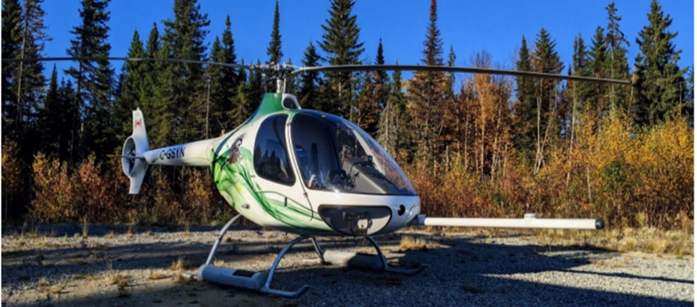
The helicopter was equipped with a nose boom, or ‘stinger’, containing a magnetometer.
Guimbal Cabri G2 C-GSYN of Synergy Aviation with Novatem Magnetometer Sensor Boom or ‘Stinger’ (Credit: Pilot via TSB)
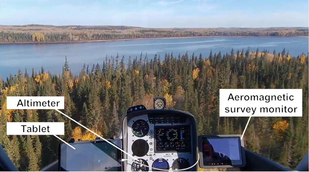
The Novatem aeromagnetic survey monitor, mounted to the right of the console directly in front of the pilot, displayed the survey blocks and flight tracks.
Cockpit View Guimbal Cabri G2 C-GSYN of Synergy Aviation with (Credit: Pilot via TSB, with TSB Annotation)
It displayed height above sea level but did not display height above ground because the helicopter was not equipped with a radar altimeter.
A conventional barometric altimeter was the only instrument on board that provided a useable indication of the helicopter’s altitude.
Importantly:
To obtain quality data, the helicopter must consistently maintain the optimal height (approximately 25 m [82 feet] over land and water) on all survey lines. This means that the helicopter is required to fly the contour of the terrain as much as possible.
Novatem has stated that some variations in height due to obstacles and other safety concerns are acceptable, and data collected can be corrected with software calculations and extrapolation algorithms.
However:
While some pilots, including the occurrence pilot, had been briefed verbally by the chief pilot on the requirement to fly the contour of the terrain, the requirement to fly at and maintain the optimal height of 25 m (82 feet) was not clearly communicated.
Neither the requirement to fly and maintain the optimal height of 25 m (82 feet) nor the requirement to fly the contour of the terrain was included in the GASP.
As it was not part of the Operations Manual, the GASP was not reviewed by the regulator, Transport Canada.
Without the integration of a precise height indication on board, the pilots were left to visually estimate and rely solely on feedback from Novatem to determine whether they had flown a proper flight profile at the correct height. This also left them to determine and maintain their height using visual cues only.
In relation to training to prepare for this type of geophysical survey:
…in-flight training was performed at 200 feet above a runway, using the runway’s left edge, centreline, and right edge to simulate track spacing. This training did not include flights at heights that would be flown operational.
The in-flight training included a flight over a lake, but at heights of up to 2000 feet AGL because the emergency flotation equipment [see below] was not installed at the time.
Before actual surveys commenced the helicopter was fitted with an Emergency Flotation System (EFS) and an Automatic Float Deployment System (AFDS). The EFS required arming before it could be activated by the AFDS or manually.
Synergy voluntarily introduced a Safety Management System (SMS) in 2017, there being no Canadian SMS regulation applicable to their type of operations (unlike in Europe for example). Its effectiveness is implicitly questioned by TSB as:
…several pilots had verbally raised concerns with the chief pilot about the low heights required for survey flights. They deemed the flight profile risky and were often uncomfortable with these low heights.
The investigation did not reveal any entries or follow-ups in the online reporting tool.. These concerns were managed informally with guidance to “fly as low as safe.”
No risk assessments were found for the equipment used or for the new location for the Novatem aeromagnetic survey operation.
The Accident Flight
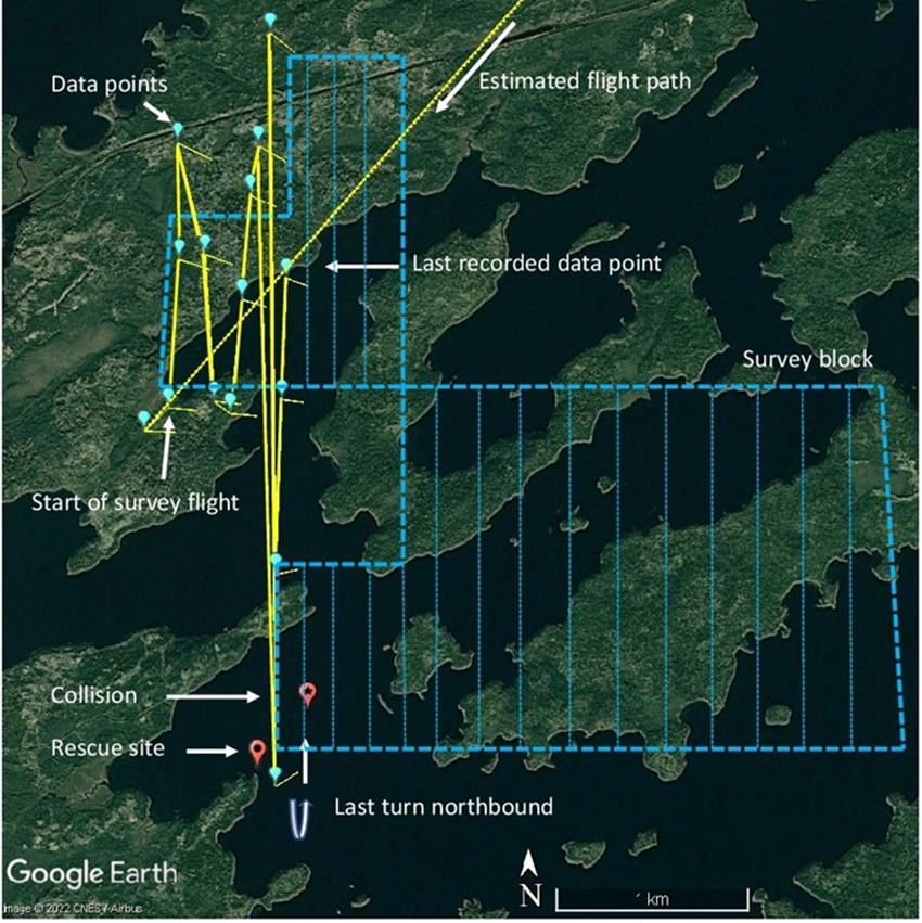
After a brief delay due to fog, the helicopter departed Chapais at 10:30 Local Time, arriving at the survey block at around 11:13.
The area surrounding Wachigabau Lake is uninhabited and required the pilot to fly over both heavily forested areas and large bodies of water. The pilot descended to the operating height, which was below 100 feet AGL, positioned the helicopter on the western edge of the survey block, and began flying north-south track lines. To ensure the accuracy of the spacing between each line, the pilot relied on the Novatem aeromagnetic survey monitor. As the aircraft moved eastward within the survey block, the survey grid lines required flight over large areas of the lake. The helicopter was…equipped with Spidertracks, a satellite flight-tracking system that records the following parameters every 2 minutes: GPS position, altitude ASL, date, time, ground speed, and direction of flight.
The average ground speed recorded during the final 31 minutes of the flight was 59 knots. The altitudes recorded varied depending upon whether the helicopter flew over land or water. The average heights recorded during the final 31 minutes of the flight were 124 feet over land and 54 feet over water. The lowest recorded heights were 77 feet over land and 26 feet over water.
Of note is that…
Having completed 2 days of survey flying (on 5 and 6 October 2021), the occurrence pilot was informed by Novatem that the survey data for both days showed that he was, on average, 10 m (32 feet) above the survey heights flown by the previous pilot, and that the survey height should be lowered. After discussing the situation with the chief pilot, the occurrence pilot adjusted his flight profile by flying lower on 7 October. Novatem was then satisfied with the survey results from that day.
TSB examined Spidertracks data from other pilot’s geophysical survey flights conducted which showed “a similar pattern of flying from 60 to 80 feet over land and from 20 to 40 feet over water”. Its not clear if there was any discussion about the over water height being so much lower that the 82 ft ‘ideal’.
At 11:44, the pilot had completed a left turn over water approximately 400 m from the western shoreline and was beginning to fly a northbound leg. The pilot manoeuvred the helicopter to correct the track being flown to ensure proper alignment and lateral spacing on the leg. During this course correction, the helicopter descended, struck the surface of the lake, and overturned
At the time of the occurrence, there was no fog in the vicinity of Wachigabau Lake, the winds were calm, and the visibility was unlimited. Due to the calm winds, glassy water conditions were present.
Photograph Taken By Pilot from Shore Shortly After the Accident (Credit: via TSB)
The US Federal Aviation Administration (FAA) provides the following caution with respect to calm wind conditions: “the smooth water surface presents a uniform appearance from above, somewhat like a mirror. This situation eliminates visual references for the pilot and can be extremely deceptive.”
Aerossurance has discussed the issues of glassy water previously:
Industry Safety Standards: The Flight Safety Foundation (FSF) and International Airborne Geophysics Safety Association (IAGSA)
Low altitude geophysical surveys are a particular demanding type of survey, very different from higher altitude aerial photogrammetry or offshore windfarm bird surveys for example, and regulations rarely prescribe specific survey orientated requirements.
Consequently, one industry association, IAGSA, have issued a Safety Policy Manual and it is a condition of membership “that members undertake to follow the practices in the Safety Policy Manual”. This notes that:
Flying the helicopter at a lower height reduces safety margins from a CFIT perspective and the combination of lower survey speed and lower height may also place the helicopter in the avoid area of its published height-velocity diagram, making a successful autorotation unlikely in the event of an engine failure.
Meanwhile, TSB explain that the FSF, an “independent, international, and impartial non-profit that exists to champion the cause of aviation safety”…
…has developed the Basic Aviation Risk Standard (BARS) as an international aviation safety program designed to provide a standard to assist in the risk-based management of aviation activities.
The FSF designed the program to suit any organization that uses aircraft operators to provide contracted aviation support for its operations.
It is a risk-based model framed against the actual threats posed to aviation operations that links threats to associated controls and recovery and mitigation measures.
An overview of the threats, associated controls, and recovery measures for airborne geophysical survey operations are provided in the BARS Bow Tie Risk Model.
Basic Aviation Risk Standard (BARS) – Contracted Aircraft Operations, Version 8 (May 2020) Appendix 6 Airborne Geophysical Survey Operations Bow Tie (Credit: FSF)
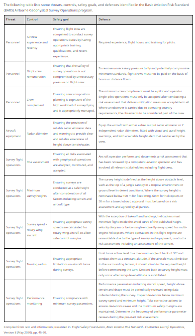
TSB also summarised some key survey threats, controls, safety goals and defences identified in BARS:
Survivability, Flight Following & Emergency Response
The helicopter’s EFS did not activate and the cockpit immediately flooded with water as the helicopter began to sink.
…the pilot reported not having time to manually inflate the [emergency flotation] system.
The investigation was unable to determine the position of the arming switch or whether the system malfunctioned due to the impact sequence.
There is no mention of what the operator’s EFS arming policy was.
TSB report that remarkably the pilot was wearing a marine Mustang MD 3157 Personal Flotation Device (PFD) which automatically inflated underwater while he was still wearing his 4-point lap strap and shoulder harness. It was marked as Transport Canada approved, but this was for marine use. Use of marine lifejackets with auto-inflation is exceptionally dangerous and has proved fatal in helicopters before.
Aviation lifejackets do not auto-inflate specifically to prevent the wearer being trapped inside the wreckage in the event of a ditching or water impact. It is why airline passenger safety briefings specifically emphasise only inflating lifejackets after you have left the aircraft.
Synergy had arranged for helicopter underwater escape training (HUET) for some pilots. Fortuitously the pilot had completed HUET just 5 weeks before and:
Despite the pilot’s initial shock and surprise, and even though his mobility was restricted with the inflated PFD, he was able to unbuckle and untangle himself from the lap belt and shoulder harness, disconnect the helmet communication cord, and egress the helicopter.
The pilot started swimming to nearest shore, which was over 425 m. After c 40 minutes, the pilot reached the shore. This may seem slow but, in general, wearing a lifejacket will slow the wearer down as a side effect of its other benefits. Once ashore the pilot started a fire and began drying his clothes and mobile phone. The survival pack had sunk with the helicopter.
No emergency locator transmitter (ELT) distress beacon signal was captured by the Cospas-Sarsat system.
This is to be expected for a fixed ELT when an aircraft sinks. The operator had fitted a Spidertracks satellite tracking system, that was meant to be monitored by “junior pilots” at their base but a key safeguard was missed because it was…..
…set to normal mode instead of watch mode. In watch mode, an alert is automatically activated if communication with the aircraft is lost for a period of 10 minutes.
The lack of position updates was not noticed by the operator’s personnel for reasons the TSB do not elaborate on, but the customer project manager, who had access to Spidertracks, observed that the helicopter’s position had not changed at c12:00. They only contacted the operator at 12:46, presumably having expected greater vigilance from the operator.
At approximately 12:50 [over an hour after the last Spidertracks position report was received], Synergy initiated its overdue aircraft procedures and sent text messages to the pilot at 12:55 and 12:58.
Its not clear how long they were prepared to wait without a response as the operator’s Emergency Response Plan (ERP) is not discussed by TSB.
At 13:22 the pilot [who had been drying out their mobile phone] received text messages from Synergy’s operations manager and its flight follower, as well as the technician from Novatem. The pilot responded and informed them of his situation.
Incredibly it took another 40 minutes, (over 2¼ hours after the water impact) for the Synergy Operations Manager to alert the Joint Rescue Coordination Centre (JRCC) in Trenton, Ontario.
The pilot was located at 16:10 by a [RCAF] CC-130Hercules aircraft. At 16:41 [almost 5 hours after the accident], a [RCAF] CH-146Griffon helicopter rescued the pilot and took him to the Chibougamau Hospital.
The submerged wreckage of the helicopter was not found or recovered.
Pilot Hours, Competence, Operational Control and ‘Commercial Pressure’
In this case the pilot’s experience, measured in terms of total flying hours, was relatively low (407 hours total, 235 on type). TSB comment that requirements for…
…minimum total flying hours or operational flying experience seems to provide operators and clients with the confidence that the pilots chosen to conduct the specific work have the operational flying experience needed for the task.
We would note that while that could be the case, there can also be a vast mismatch between the actual expertise needed for the task and the experience that has previously been accrued. The quality and relevance of each flying hour is not the same! We discussed this in 2015: Wait to Weight & Balance – Lessons from a Loss of Control. This was a PC-12 serious incident involving loading where we noted that…
…the pilot was qualified on ‘A-310, AVR-146, B-737, B-757, B-767, B-777, BAE-146, DC-9, LR-JET’ they had only converted to the PC-12 a few weeks prior. Acting a single pilot on PC-12 introduces duties that are not normally routinely practised by airline pilots.
This perhaps explains why a TSB safety study into Canada’s air-taxi industry that examined 716 accidents that occurred between 2000 to 2014 and analysis of 124 interviews indicated that [emphasis added]…
…while a large proportion of inexperienced personnel in an organization is seen as posing a higher risk to safety, there was only one accident category (fuel-related accidents) in which pilots with relatively fewer flight hours were involved. In all other accident categories, the pilots involved had a higher average number of flight hours.
When looking at experience in PDM [pilot decision making], pilots on both ends of the experience spectrum were at risk for ineffective decision making, although for different reasons. Operators described inexperience as a factor that made it more difficult to identify and assess risks.
However, TSB noted a paradox that…
…as pilots gain more experience, their perception of risk will often change, making them more willing to take risks.
We would argue that competence for the task (possessing the necessary knowledge, skills and attitudes) is more important and a more meaningful criteria. BARS for example already contains an Annex with a Flight Crew Competency Based Training Framework as an alternative to meeting minimum flying hours.
Setting a competency performance standard and the assessment of competence (an outcome of a person’s training and experience) are however more challenging than simply checking one input to competency against a non-evidenced based requirement, namely the totals on the last page of a log book…
In this case, the geophysical survey task demanded specific low flying skills. Additionally the operational scenario also demanded certain technical (risk assessment) and non-technical skills when not flying. This was because a ‘Type D operational control system’ was in place for these survey flights. This…
…delegates operational control from the operations manager to the pilot-in-command. The pilot-in-command is therefore responsible for all pre-flight duties, including weather assessments and risk analysis.
In other words the pilots…
…were basically left to operate alone and deal directly with the client. Operating alone can leave pilots with few resources to assist in decision making, identifying hazards and risks, or trying to select mitigating options or courses of action, especially when those pilots have low levels of experience.
Operational pressures may lead…pilots to accept unsafe practices.
Synergy did describe such operational and/or commercial pressures in their training:
Company: Pressure to complete tasks
Customer: Pressure to please the customer in spite of safety
Self: Desire to accomplish more than is reasonable
Peers: Pressure to perform at the perceived level of others (culture)
External: Distractions from the job at hand (family/finances/personal)
Further in their procedures they state:
Should there be any pressure or dispute from a client without resolving the dispute, the PIC shall terminate the flight and contact management in order to resolve the dispute. At no point shall a pilot feel pressured during any phase of flight operations to do anything they are not comfortable with.
Our observation is that even with clear guidance, recognising and resisting these pressures can be difficult, though they are an essential skill for pilots. However, it is a skill that is not developed equally during every flying hour.
Furthermore their employers and end customers also need to be sensitive to creating inappropriate or unintended pressures.
Operational / Commercial Pressure Safety Case Studies
The routine practice of descending and flying below 25 m (82 feet) when over water or flat, open fields, left the occurrence pilot insufficient height or time to detect and react to operational hazards.
While flying at low level over the lake, the mirror effect of the glassy water resulted in a reduction of visual cues needed for depth perception. Consequently, an inadvertent descent went unnoticed by the pilot and the helicopter collided with the surface of the lake.
They also note that…
….following this occurrence, the GASP was amended to include the following statement: “All flights shall be conducted no lower than 200ftAGL.”[emphasis in original]
Aerossurance has extensive air safety, flight operations, survey operations, SAR/ERP, airworthiness, human factors, aviation regulation and safety analysis experience. For practical aviation advice you can trust, contact us at: enquiries@aerossurance.com